You are here: Home > Network List > TA - USArray Transportable Network (new EarthScope stations) Stations List
> Station O19K Port Alsworth, AK, USA > Earthquake Result Viewer
O19K Port Alsworth, AK, USA - Earthquake Result Viewer
| Earthquake location: |
Vanuatu Islands |
| Earthquake latitude/longitude: |
-14.4/166.8 |
| Earthquake time(UTC): |
2016/04/03 (094) 08:23:53 GMT |
| Earthquake Depth: |
35 km |
| Earthquake Magnitude: |
6.9 MWW, 7.2 MI |
| Earthquake Catalog/Contributor: |
NEIC PDE/NEIC COMCAT |
|
| Network: |
TA USArray Transportable Network (new EarthScope stations) |
| Station: |
O19K Port Alsworth, AK, USA |
| Lat/Lon: |
60.20 N/154.32 W |
| Elevation: |
96 m |
|
| Distance: |
80.6 deg |
| Az: |
18.525 deg |
| Baz: |
218.053 deg |
| Ray Param: |
0.048130296 |
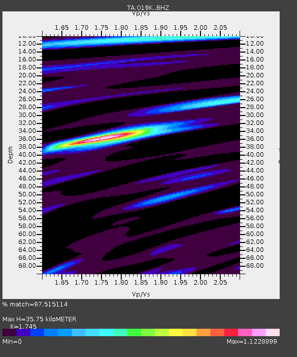
| Estimated Moho Depth: |
35.75 km |
| Estimated Crust Vp/Vs: |
1.75 |
| Assumed Crust Vp: |
6.566 km/s |
| Estimated Crust Vs: |
3.763 km/s |
| Estimated Crust Poisson's Ratio: |
0.26 |
|
| Radial Match: |
97.515114 % |
| Radial Bump: |
400 |
| Transverse Match: |
89.90654 % |
| Transverse Bump: |
400 |
| SOD ConfigId: |
7422571 |
| Insert Time: |
2019-04-22 03:35:17.322 +0000 |
| GWidth: |
2.5 |
| Max Bumps: |
400 |
| Tol: |
0.001 |
|

Signal To Noise
| Channel | StoN | STA | LTA |
| TA:O19K: :BHZ:20160403T08:35:30.950024Z | 29.815676 | 4.4807152E-6 | 1.5028053E-7 |
| TA:O19K: :BHN:20160403T08:35:30.950024Z | 12.436423 | 1.3951077E-6 | 1.1217917E-7 |
| TA:O19K: :BHE:20160403T08:35:30.950024Z | 6.625606 | 8.196914E-7 | 1.237157E-7 |
| Arrivals |
| Ps | 4.2 SECOND |
| PpPs | 15 SECOND |
| PsPs/PpSs | 19 SECOND |


