You are here: Home > Network List > TA - USArray Transportable Network (new EarthScope stations) Stations List
> Station P19K Oil Pt, AK, USA > Earthquake Result Viewer
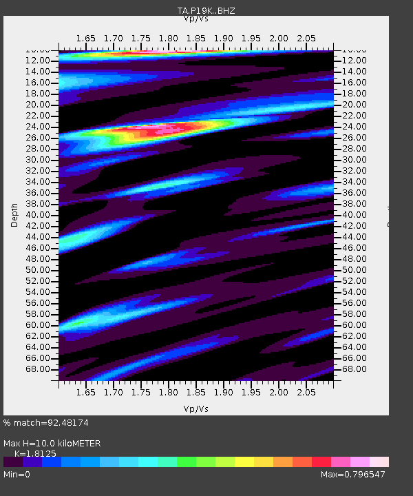
P19K Oil Pt, AK, USA - Earthquake Result Viewer
| Earthquake location: |
Vanuatu Islands |
| Earthquake latitude/longitude: |
-14.4/166.8 |
| Earthquake time(UTC): |
2016/04/03 (094) 08:23:53 GMT |
| Earthquake Depth: |
35 km |
| Earthquake Magnitude: |
6.9 MWW, 7.2 MI |
| Earthquake Catalog/Contributor: |
NEIC PDE/NEIC COMCAT |
|
| Network: |
TA USArray Transportable Network (new EarthScope stations) |
| Station: |
P19K Oil Pt, AK, USA |
| Lat/Lon: |
59.65 N/153.23 W |
| Elevation: |
629 m |
|
| Distance: |
80.5 deg |
| Az: |
19.303 deg |
| Baz: |
219.121 deg |
| Ray Param: |
0.048186775 |
| Estimated Moho Depth: |
10.0 km |
| Estimated Crust Vp/Vs: |
1.81 |
| Assumed Crust Vp: |
5.989 km/s |
| Estimated Crust Vs: |
3.304 km/s |
| Estimated Crust Poisson's Ratio: |
0.28 |
|
| Radial Match: |
92.48174 % |
| Radial Bump: |
400 |
| Transverse Match: |
89.449776 % |
| Transverse Bump: |
400 |
| SOD ConfigId: |
7422571 |
| Insert Time: |
2019-04-22 03:35:19.191 +0000 |
| GWidth: |
2.5 |
| Max Bumps: |
400 |
| Tol: |
0.001 |
|

Signal To Noise
| Channel | StoN | STA | LTA |
| TA:P19K: :BHZ:20160403T08:35:30.500012Z | 15.4147005 | 7.0361434E-6 | 4.564567E-7 |
| TA:P19K: :BHN:20160403T08:35:30.500012Z | 6.840974 | 1.7060694E-6 | 2.4938984E-7 |
| TA:P19K: :BHE:20160403T08:35:30.500012Z | 3.551436 | 1.0284996E-6 | 2.8960108E-7 |
| Arrivals |
| Ps | 1.4 SECOND |
| PpPs | 4.6 SECOND |
| PsPs/PpSs | 6.0 SECOND |


