You are here: Home > Network List > TA - USArray Transportable Network (new EarthScope stations) Stations List
> Station R11A Troy Canyon, Currant, NV, USA > Earthquake Result Viewer
R11A Troy Canyon, Currant, NV, USA - Earthquake Result Viewer
| Earthquake location: |
Vanuatu Islands |
| Earthquake latitude/longitude: |
-14.4/166.8 |
| Earthquake time(UTC): |
2016/04/03 (094) 08:23:53 GMT |
| Earthquake Depth: |
35 km |
| Earthquake Magnitude: |
6.9 MWW, 7.2 MI |
| Earthquake Catalog/Contributor: |
NEIC PDE/NEIC COMCAT |
|
| Network: |
TA USArray Transportable Network (new EarthScope stations) |
| Station: |
R11A Troy Canyon, Currant, NV, USA |
| Lat/Lon: |
38.35 N/115.59 W |
| Elevation: |
1756 m |
|
| Distance: |
89.3 deg |
| Az: |
50.171 deg |
| Baz: |
251.195 deg |
| Ray Param: |
0.041876923 |
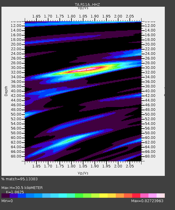
| Estimated Moho Depth: |
30.5 km |
| Estimated Crust Vp/Vs: |
1.86 |
| Assumed Crust Vp: |
6.276 km/s |
| Estimated Crust Vs: |
3.37 km/s |
| Estimated Crust Poisson's Ratio: |
0.30 |
|
| Radial Match: |
95.13383 % |
| Radial Bump: |
303 |
| Transverse Match: |
66.67011 % |
| Transverse Bump: |
400 |
| SOD ConfigId: |
7422571 |
| Insert Time: |
2019-04-22 03:35:22.921 +0000 |
| GWidth: |
2.5 |
| Max Bumps: |
400 |
| Tol: |
0.001 |
|

Signal To Noise
| Channel | StoN | STA | LTA |
| TA:R11A: :HHZ:20160403T08:36:14.729993Z | 13.660196 | 2.349166E-6 | 1.719716E-7 |
| TA:R11A: :HHN:20160403T08:36:14.729993Z | 1.8567568 | 3.2202502E-7 | 1.7343415E-7 |
| TA:R11A: :HHE:20160403T08:36:14.729993Z | 12.924131 | 8.549176E-7 | 6.614894E-8 |
| Arrivals |
| Ps | 4.3 SECOND |
| PpPs | 14 SECOND |
| PsPs/PpSs | 18 SECOND |


