You are here: Home > Network List > XD14 - Illuminating the architecture of the greater Mount St. Helens magmatic systems f Stations List
> Station MD05 "Mount St Helens, WA" > Earthquake Result Viewer
MD05 "Mount St Helens, WA" - Earthquake Result Viewer
| Earthquake location: |
Vanuatu Islands |
| Earthquake latitude/longitude: |
-14.4/166.8 |
| Earthquake time(UTC): |
2016/04/03 (094) 08:23:53 GMT |
| Earthquake Depth: |
35 km |
| Earthquake Magnitude: |
6.9 MWW, 7.2 MI |
| Earthquake Catalog/Contributor: |
NEIC PDE/NEIC COMCAT |
|
| Network: |
XD Illuminating the architecture of the greater Mount St. Helens magmatic systems f |
| Station: |
MD05 "Mount St Helens, WA" |
| Lat/Lon: |
46.52 N/122.28 W |
| Elevation: |
718 m |
|
| Distance: |
87.7 deg |
| Az: |
40.77 deg |
| Baz: |
246.435 deg |
| Ray Param: |
0.04311649 |
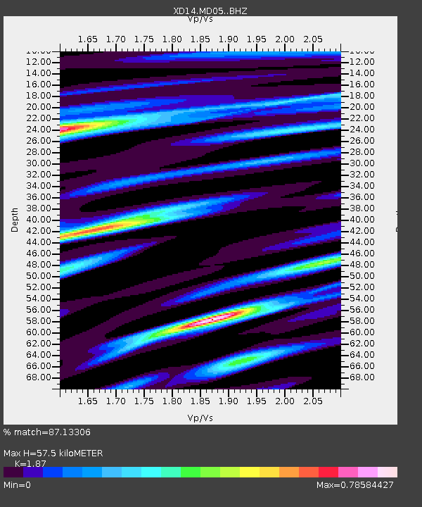
| Estimated Moho Depth: |
57.5 km |
| Estimated Crust Vp/Vs: |
1.87 |
| Assumed Crust Vp: |
6.566 km/s |
| Estimated Crust Vs: |
3.511 km/s |
| Estimated Crust Poisson's Ratio: |
0.30 |
|
| Radial Match: |
87.13306 % |
| Radial Bump: |
400 |
| Transverse Match: |
72.50205 % |
| Transverse Bump: |
400 |
| SOD ConfigId: |
7422571 |
| Insert Time: |
2019-04-22 03:36:25.473 +0000 |
| GWidth: |
2.5 |
| Max Bumps: |
400 |
| Tol: |
0.001 |
|

Signal To Noise
| Channel | StoN | STA | LTA |
| XD:MD05: :BHZ:20160403T08:36:06.81001Z | 14.496891 | 3.227882E-6 | 2.2266029E-7 |
| XD:MD05: :BHN:20160403T08:36:06.81001Z | 1.3399589 | 2.7527582E-7 | 2.0543601E-7 |
| XD:MD05: :BHE:20160403T08:36:06.81001Z | 3.7718368 | 1.0364314E-6 | 2.7478163E-7 |
| Arrivals |
| Ps | 7.8 SECOND |
| PpPs | 25 SECOND |
| PsPs/PpSs | 32 SECOND |


