You are here: Home > Network List > CI - Caltech Regional Seismic Network Stations List
> Station BAR Barrett, Tecate, CA, USA > Earthquake Result Viewer
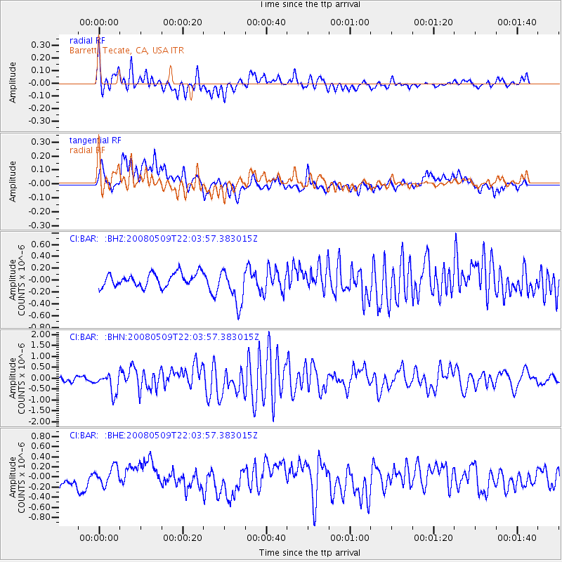
BAR Barrett, Tecate, CA, USA - Earthquake Result Viewer
*The percent match for this event was below the threshold and hence no stack was calculated.
| Earthquake location: |
South Of Mariana Islands |
| Earthquake latitude/longitude: |
12.5/143.2 |
| Earthquake time(UTC): |
2008/05/09 (130) 21:51:29 GMT |
| Earthquake Depth: |
76 km |
| Earthquake Magnitude: |
6.1 MB, 6.7 MW, 6.7 MW |
| Earthquake Catalog/Contributor: |
WHDF/NEIC |
|
| Network: |
CI Caltech Regional Seismic Network |
| Station: |
BAR Barrett, Tecate, CA, USA |
| Lat/Lon: |
32.68 N/116.67 W |
| Elevation: |
521 m |
|
| Distance: |
91.7 deg |
| Az: |
56.151 deg |
| Baz: |
285.912 deg |
| Ray Param: |
$rayparam |
*The percent match for this event was below the threshold and hence was not used in the summary stack. |
|
| Radial Match: |
68.468285 % |
| Radial Bump: |
400 |
| Transverse Match: |
69.025536 % |
| Transverse Bump: |
400 |
| SOD ConfigId: |
2504 |
| Insert Time: |
2010-02-26 00:12:09.943 +0000 |
| GWidth: |
2.5 |
| Max Bumps: |
400 |
| Tol: |
0.001 |
|
Signal To Noise
| Channel | StoN | STA | LTA |
| CI:BAR: :BHN:20080509T22:03:57.383015Z | 5.1197376 | 4.6637547E-7 | 9.109363E-8 |
| CI:BAR: :BHE:20080509T22:03:57.383015Z | 1.1211416 | 1.6668783E-7 | 1.4867689E-7 |
| CI:BAR: :BHZ:20080509T22:03:57.383015Z | 2.8096397 | 3.1195862E-7 | 1.1103153E-7 |
| Arrivals |
| Ps | |
| PpPs | |
| PsPs/PpSs | |


