You are here: Home > Network List > XD14 - Illuminating the architecture of the greater Mount St. Helens magmatic systems f Stations List
> Station MH09 "Mount St Helens, WA" > Earthquake Result Viewer
MH09 "Mount St Helens, WA" - Earthquake Result Viewer
| Earthquake location: |
Vanuatu Islands |
| Earthquake latitude/longitude: |
-14.4/166.8 |
| Earthquake time(UTC): |
2016/04/03 (094) 08:23:53 GMT |
| Earthquake Depth: |
35 km |
| Earthquake Magnitude: |
6.9 MWW, 7.2 MI |
| Earthquake Catalog/Contributor: |
NEIC PDE/NEIC COMCAT |
|
| Network: |
XD Illuminating the architecture of the greater Mount St. Helens magmatic systems f |
| Station: |
MH09 "Mount St Helens, WA" |
| Lat/Lon: |
46.30 N/121.80 W |
| Elevation: |
989 m |
|
| Distance: |
87.9 deg |
| Az: |
41.109 deg |
| Baz: |
246.792 deg |
| Ray Param: |
0.042957984 |
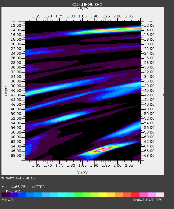
| Estimated Moho Depth: |
65.25 km |
| Estimated Crust Vp/Vs: |
1.93 |
| Assumed Crust Vp: |
6.597 km/s |
| Estimated Crust Vs: |
3.41 km/s |
| Estimated Crust Poisson's Ratio: |
0.32 |
|
| Radial Match: |
87.4846 % |
| Radial Bump: |
400 |
| Transverse Match: |
69.682365 % |
| Transverse Bump: |
400 |
| SOD ConfigId: |
7422571 |
| Insert Time: |
2019-04-22 03:36:39.620 +0000 |
| GWidth: |
2.5 |
| Max Bumps: |
400 |
| Tol: |
0.001 |
|

Signal To Noise
| Channel | StoN | STA | LTA |
| XD:MH09: :BHZ:20160403T08:36:07.825024Z | 17.16411 | 2.6489117E-6 | 1.5432852E-7 |
| XD:MH09: :BHN:20160403T08:36:07.825024Z | 1.4167401 | 2.648689E-7 | 1.869566E-7 |
| XD:MH09: :BHE:20160403T08:36:07.825024Z | 6.0488467 | 8.2828757E-7 | 1.3693314E-7 |
| Arrivals |
| Ps | 9.4 SECOND |
| PpPs | 28 SECOND |
| PsPs/PpSs | 38 SECOND |


