You are here: Home > Network List > XD14 - Illuminating the architecture of the greater Mount St. Helens magmatic systems f Stations List
> Station MK10 "Mount St Helens, WA" > Earthquake Result Viewer
MK10 "Mount St Helens, WA" - Earthquake Result Viewer
| Earthquake location: |
Vanuatu Islands |
| Earthquake latitude/longitude: |
-14.4/166.8 |
| Earthquake time(UTC): |
2016/04/03 (094) 08:23:53 GMT |
| Earthquake Depth: |
35 km |
| Earthquake Magnitude: |
6.9 MWW, 7.2 MI |
| Earthquake Catalog/Contributor: |
NEIC PDE/NEIC COMCAT |
|
| Network: |
XD Illuminating the architecture of the greater Mount St. Helens magmatic systems f |
| Station: |
MK10 "Mount St Helens, WA" |
| Lat/Lon: |
46.14 N/121.77 W |
| Elevation: |
1186 m |
|
| Distance: |
87.8 deg |
| Az: |
41.258 deg |
| Baz: |
246.819 deg |
| Ray Param: |
0.04298866 |
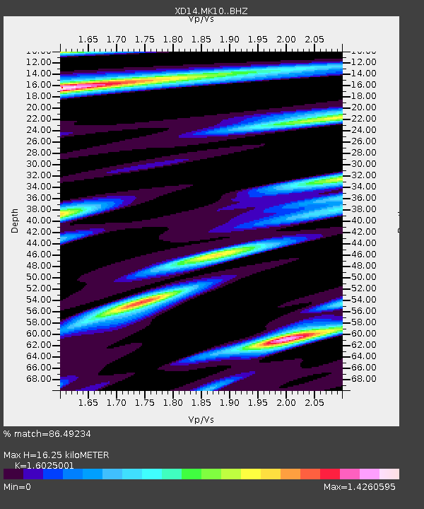
| Estimated Moho Depth: |
16.25 km |
| Estimated Crust Vp/Vs: |
1.60 |
| Assumed Crust Vp: |
6.597 km/s |
| Estimated Crust Vs: |
4.117 km/s |
| Estimated Crust Poisson's Ratio: |
0.18 |
|
| Radial Match: |
86.49234 % |
| Radial Bump: |
400 |
| Transverse Match: |
70.03141 % |
| Transverse Bump: |
400 |
| SOD ConfigId: |
7422571 |
| Insert Time: |
2019-04-22 03:36:51.007 +0000 |
| GWidth: |
2.5 |
| Max Bumps: |
400 |
| Tol: |
0.001 |
|

Signal To Noise
| Channel | StoN | STA | LTA |
| XD:MK10: :BHZ:20160403T08:36:07.625012Z | 15.21296 | 3.0249937E-6 | 1.988432E-7 |
| XD:MK10: :BHN:20160403T08:36:07.625012Z | 1.0909958 | 4.4938608E-7 | 4.1190452E-7 |
| XD:MK10: :BHE:20160403T08:36:07.625012Z | 3.0118532 | 1.1228606E-6 | 3.7281382E-7 |
| Arrivals |
| Ps | 1.5 SECOND |
| PpPs | 6.2 SECOND |
| PsPs/PpSs | 7.8 SECOND |


