You are here: Home > Network List > XD14 - Illuminating the architecture of the greater Mount St. Helens magmatic systems f Stations List
> Station MN09 "Mount St Helens, WA" > Earthquake Result Viewer
MN09 "Mount St Helens, WA" - Earthquake Result Viewer
| Earthquake location: |
Vanuatu Islands |
| Earthquake latitude/longitude: |
-14.4/166.8 |
| Earthquake time(UTC): |
2016/04/03 (094) 08:23:53 GMT |
| Earthquake Depth: |
35 km |
| Earthquake Magnitude: |
6.9 MWW, 7.2 MI |
| Earthquake Catalog/Contributor: |
NEIC PDE/NEIC COMCAT |
|
| Network: |
XD Illuminating the architecture of the greater Mount St. Helens magmatic systems f |
| Station: |
MN09 "Mount St Helens, WA" |
| Lat/Lon: |
46.00 N/121.84 W |
| Elevation: |
1254 m |
|
| Distance: |
87.7 deg |
| Az: |
41.371 deg |
| Baz: |
246.773 deg |
| Ray Param: |
0.043064304 |
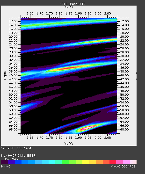
| Estimated Moho Depth: |
67.0 km |
| Estimated Crust Vp/Vs: |
1.95 |
| Assumed Crust Vp: |
6.597 km/s |
| Estimated Crust Vs: |
3.392 km/s |
| Estimated Crust Poisson's Ratio: |
0.32 |
|
| Radial Match: |
86.04264 % |
| Radial Bump: |
379 |
| Transverse Match: |
70.38147 % |
| Transverse Bump: |
400 |
| SOD ConfigId: |
7422571 |
| Insert Time: |
2019-04-22 03:36:58.446 +0000 |
| GWidth: |
2.5 |
| Max Bumps: |
400 |
| Tol: |
0.001 |
|

Signal To Noise
| Channel | StoN | STA | LTA |
| XD:MN09: :BHZ:20160403T08:36:07.144971Z | 12.195218 | 2.97862E-6 | 2.4424492E-7 |
| XD:MN09: :BHN:20160403T08:36:07.144971Z | 0.5841812 | 2.3589192E-7 | 4.0379922E-7 |
| XD:MN09: :BHE:20160403T08:36:07.144971Z | 3.9803443 | 1.0820553E-6 | 2.7184967E-7 |
| Arrivals |
| Ps | 9.8 SECOND |
| PpPs | 29 SECOND |
| PsPs/PpSs | 39 SECOND |


