You are here: Home > Network List > US - United States National Seismic Network Stations List
> Station LKWY Lake (Yellowstone--Lake), Wyoming, USA > Earthquake Result Viewer
LKWY Lake (Yellowstone--Lake), Wyoming, USA - Earthquake Result Viewer
| Earthquake location: |
Chile-Bolivia Border Region |
| Earthquake latitude/longitude: |
-22.7/-67.9 |
| Earthquake time(UTC): |
2001/06/19 (170) 09:32:24 GMT |
| Earthquake Depth: |
147 km |
| Earthquake Magnitude: |
5.5 MB, 5.2 MS, 6.1 MW, 5.9 MW |
| Earthquake Catalog/Contributor: |
WHDF/NEIC |
|
| Network: |
US United States National Seismic Network |
| Station: |
LKWY Lake (Yellowstone--Lake), Wyoming, USA |
| Lat/Lon: |
44.57 N/110.40 W |
| Elevation: |
2424 m |
|
| Distance: |
77.4 deg |
| Az: |
330.331 deg |
| Baz: |
140.261 deg |
| Ray Param: |
0.049965426 |
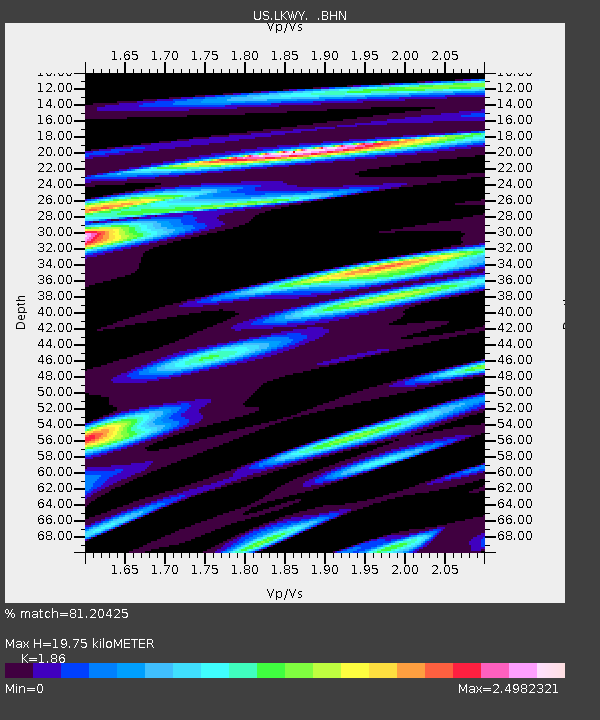
| Estimated Moho Depth: |
19.75 km |
| Estimated Crust Vp/Vs: |
1.86 |
| Assumed Crust Vp: |
6.35 km/s |
| Estimated Crust Vs: |
3.414 km/s |
| Estimated Crust Poisson's Ratio: |
0.30 |
|
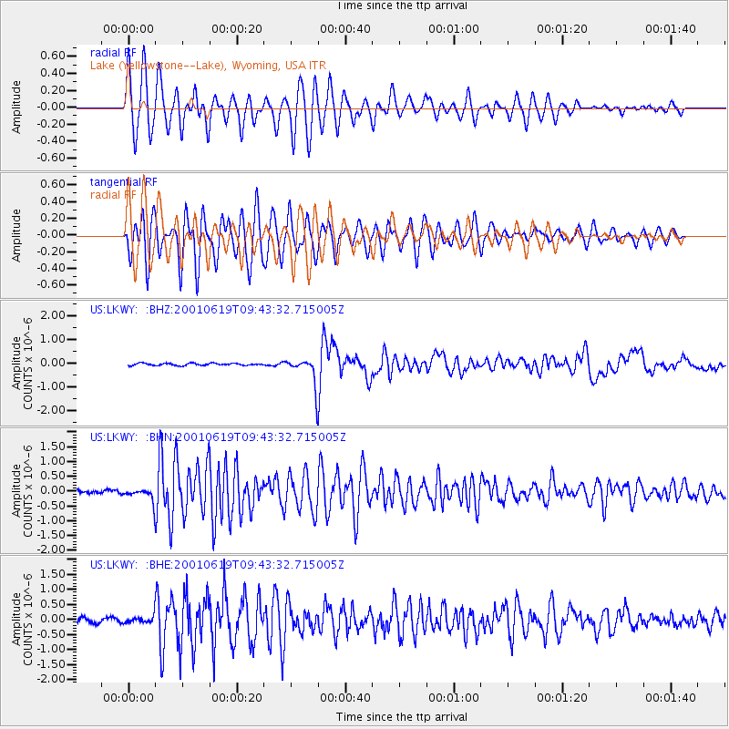
| Radial Match: |
81.20425 % |
| Radial Bump: |
400 |
| Transverse Match: |
80.73321 % |
| Transverse Bump: |
400 |
| SOD ConfigId: |
110165 |
| Insert Time: |
2010-03-05 00:55:45.066 +0000 |
| GWidth: |
2.5 |
| Max Bumps: |
400 |
| Tol: |
0.001 |
|
Signal To Noise
| Channel | StoN | STA | LTA |
| US:LKWY: :BHN:20010619T09:43:32.715005Z | 3.2593098 | 2.1518338E-7 | 6.602115E-8 |
| US:LKWY: :BHE:20010619T09:43:32.715005Z | 1.2686192 | 1.16821745E-7 | 9.208575E-8 |
| US:LKWY: :BHZ:20010619T09:43:32.715005Z | 12.791148 | 5.9234316E-7 | 4.6308834E-8 |
| Arrivals |
| Ps | 2.8 SECOND |
| PpPs | 8.6 SECOND |
| PsPs/PpSs | 11 SECOND |


