You are here: Home > Network List > CI - Caltech Regional Seismic Network Stations List
> Station BAR Barrett, Tecate, CA, USA > Earthquake Result Viewer
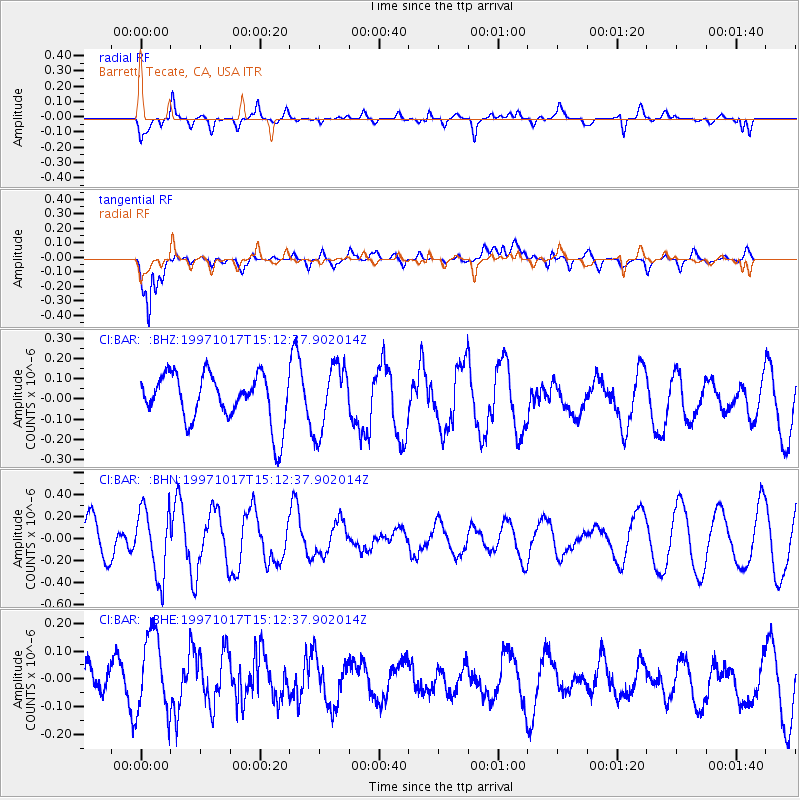
BAR Barrett, Tecate, CA, USA - Earthquake Result Viewer
*The percent match for this event was below the threshold and hence no stack was calculated.
| Earthquake location: |
Fiji Islands Region |
| Earthquake latitude/longitude: |
-20.9/-178.8 |
| Earthquake time(UTC): |
1997/10/17 (290) 15:02:00 GMT |
| Earthquake Depth: |
579 km |
| Earthquake Magnitude: |
5.3 MB, 6.0 UNKNOWN, 6.0 MW |
| Earthquake Catalog/Contributor: |
WHDF/NEIC |
|
| Network: |
CI Caltech Regional Seismic Network |
| Station: |
BAR Barrett, Tecate, CA, USA |
| Lat/Lon: |
32.68 N/116.67 W |
| Elevation: |
521 m |
|
| Distance: |
79.8 deg |
| Az: |
49.274 deg |
| Baz: |
237.169 deg |
| Ray Param: |
$rayparam |
*The percent match for this event was below the threshold and hence was not used in the summary stack. |
|
| Radial Match: |
65.33644 % |
| Radial Bump: |
400 |
| Transverse Match: |
90.08427 % |
| Transverse Bump: |
400 |
| SOD ConfigId: |
4480 |
| Insert Time: |
2010-02-26 00:12:12.602 +0000 |
| GWidth: |
2.5 |
| Max Bumps: |
400 |
| Tol: |
0.001 |
|
Signal To Noise
| Channel | StoN | STA | LTA |
| CI:BAR: :BHN:19971017T15:12:37.902014Z | 1.4808757 | 3.058519E-7 | 2.0653448E-7 |
| CI:BAR: :BHE:19971017T15:12:37.902014Z | 1.2466173 | 1.5018158E-7 | 1.2047128E-7 |
| CI:BAR: :BHZ:19971017T15:12:37.902014Z | 1.3628381 | 1.6309818E-7 | 1.1967539E-7 |
| Arrivals |
| Ps | |
| PpPs | |
| PsPs/PpSs | |


