You are here: Home > Network List > US - United States National Seismic Network Stations List
> Station LKWY Lake (Yellowstone--Lake), Wyoming, USA > Earthquake Result Viewer
LKWY Lake (Yellowstone--Lake), Wyoming, USA - Earthquake Result Viewer
| Earthquake location: |
Central Mid-Atlantic Ridge |
| Earthquake latitude/longitude: |
0.7/-30.3 |
| Earthquake time(UTC): |
2007/07/03 (184) 08:26:00 GMT |
| Earthquake Depth: |
10 km |
| Earthquake Magnitude: |
5.8 MB, 5.9 MS, 6.3 MW, 6.1 MW |
| Earthquake Catalog/Contributor: |
WHDF/NEIC |
|
| Network: |
US United States National Seismic Network |
| Station: |
LKWY Lake (Yellowstone--Lake), Wyoming, USA |
| Lat/Lon: |
44.57 N/110.40 W |
| Elevation: |
2424 m |
|
| Distance: |
82.5 deg |
| Az: |
314.736 deg |
| Baz: |
96.43 deg |
| Ray Param: |
0.046871703 |
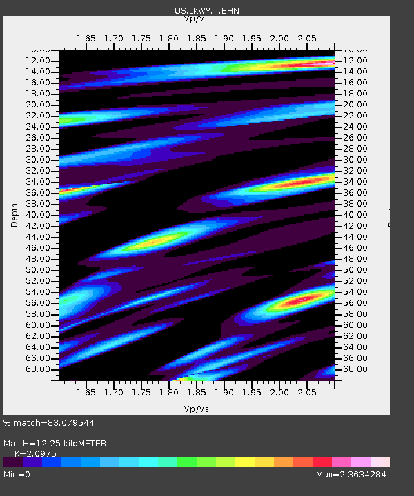
| Estimated Moho Depth: |
12.25 km |
| Estimated Crust Vp/Vs: |
2.10 |
| Assumed Crust Vp: |
6.35 km/s |
| Estimated Crust Vs: |
3.027 km/s |
| Estimated Crust Poisson's Ratio: |
0.35 |
|
| Radial Match: |
83.079544 % |
| Radial Bump: |
400 |
| Transverse Match: |
82.04544 % |
| Transverse Bump: |
400 |
| SOD ConfigId: |
2564 |
| Insert Time: |
2010-03-05 00:56:04.417 +0000 |
| GWidth: |
2.5 |
| Max Bumps: |
400 |
| Tol: |
0.001 |
|
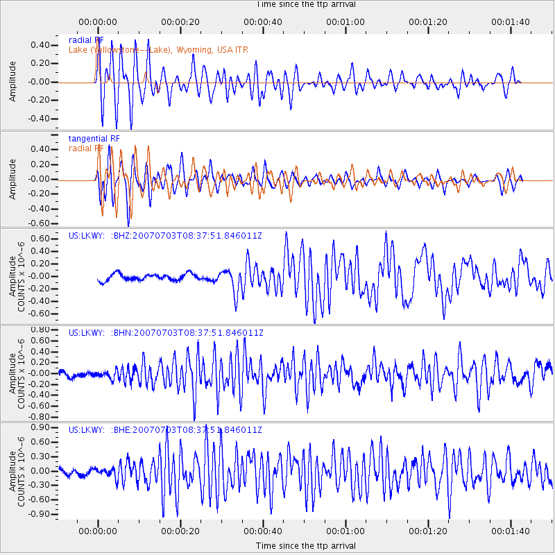
Signal To Noise
| Channel | StoN | STA | LTA |
| US:LKWY: :BHN:20070703T08:37:51.846011Z | 0.9512934 | 6.9216895E-8 | 7.2760834E-8 |
| US:LKWY: :BHE:20070703T08:37:51.846011Z | 1.5417956 | 9.793702E-8 | 6.3521405E-8 |
| US:LKWY: :BHZ:20070703T08:37:51.846011Z | 3.6644323 | 1.9004435E-7 | 5.1861882E-8 |
| Arrivals |
| Ps | 2.2 SECOND |
| PpPs | 5.8 SECOND |
| PsPs/PpSs | 8.0 SECOND |


