You are here: Home > Network List > KZ - Kazakhstan Network Stations List
> Station OTUK ORTAU, Kazakstan > Earthquake Result Viewer
OTUK ORTAU, Kazakstan - Earthquake Result Viewer
| Earthquake location: |
Talaud Islands, Indonesia |
| Earthquake latitude/longitude: |
4.2/126.7 |
| Earthquake time(UTC): |
2016/04/05 (096) 08:29:21 GMT |
| Earthquake Depth: |
35 km |
| Earthquake Magnitude: |
5.7 MWB |
| Earthquake Catalog/Contributor: |
NEIC PDE/NEIC COMCAT |
|
| Network: |
KZ Kazakhstan Network |
| Station: |
OTUK ORTAU, Kazakstan |
| Lat/Lon: |
48.24 N/72.34 E |
| Elevation: |
750 m |
|
| Distance: |
63.7 deg |
| Az: |
322.704 deg |
| Baz: |
115.301 deg |
| Ray Param: |
0.059322003 |
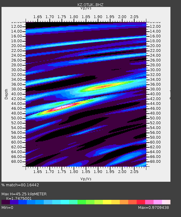
| Estimated Moho Depth: |
45.25 km |
| Estimated Crust Vp/Vs: |
1.75 |
| Assumed Crust Vp: |
6.571 km/s |
| Estimated Crust Vs: |
3.76 km/s |
| Estimated Crust Poisson's Ratio: |
0.26 |
|
| Radial Match: |
80.16442 % |
| Radial Bump: |
400 |
| Transverse Match: |
45.603462 % |
| Transverse Bump: |
400 |
| SOD ConfigId: |
7422571 |
| Insert Time: |
2019-04-22 03:41:07.560 +0000 |
| GWidth: |
2.5 |
| Max Bumps: |
400 |
| Tol: |
0.001 |
|

Signal To Noise
| Channel | StoN | STA | LTA |
| KZ:OTUK: :BHZ:20160405T08:39:14.150996Z | 1.627348 | 5.8014802E-8 | 3.5649908E-8 |
| KZ:OTUK: :BHN:20160405T08:39:14.150996Z | 1.460659 | 7.700386E-8 | 5.2718573E-8 |
| KZ:OTUK: :BHE:20160405T08:39:14.150996Z | 1.5540987 | 5.374595E-8 | 3.4583355E-8 |
| Arrivals |
| Ps | 5.4 SECOND |
| PpPs | 18 SECOND |
| PsPs/PpSs | 23 SECOND |


