You are here: Home > Network List > XL12 - Hangay Dome, Mongolia Stations List
> Station HV18 HV18 > Earthquake Result Viewer
HV18 HV18 - Earthquake Result Viewer
| Earthquake location: |
Talaud Islands, Indonesia |
| Earthquake latitude/longitude: |
4.2/126.7 |
| Earthquake time(UTC): |
2016/04/05 (096) 08:29:21 GMT |
| Earthquake Depth: |
35 km |
| Earthquake Magnitude: |
5.7 MWB |
| Earthquake Catalog/Contributor: |
NEIC PDE/NEIC COMCAT |
|
| Network: |
XL Hangay Dome, Mongolia |
| Station: |
HV18 HV18 |
| Lat/Lon: |
50.57 N/100.62 E |
| Elevation: |
1696 m |
|
| Distance: |
51.2 deg |
| Az: |
338.888 deg |
| Baz: |
145.712 deg |
| Ray Param: |
0.06752805 |
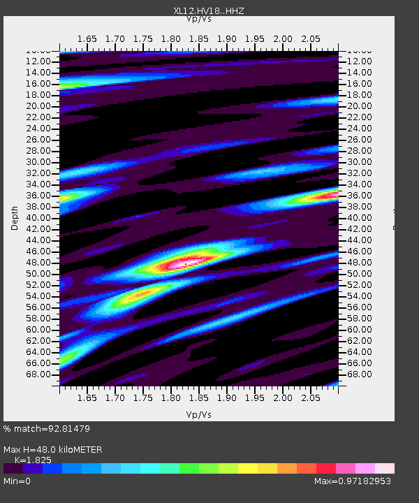
| Estimated Moho Depth: |
48.0 km |
| Estimated Crust Vp/Vs: |
1.83 |
| Assumed Crust Vp: |
6.419 km/s |
| Estimated Crust Vs: |
3.517 km/s |
| Estimated Crust Poisson's Ratio: |
0.29 |
|
| Radial Match: |
92.81479 % |
| Radial Bump: |
367 |
| Transverse Match: |
67.70857 % |
| Transverse Bump: |
400 |
| SOD ConfigId: |
7422571 |
| Insert Time: |
2019-04-22 03:42:09.257 +0000 |
| GWidth: |
2.5 |
| Max Bumps: |
400 |
| Tol: |
0.001 |
|

Signal To Noise
| Channel | StoN | STA | LTA |
| XL:HV18: :HHZ:20160405T08:37:49.718989Z | 2.7323682 | 1.2667586E-7 | 4.6361194E-8 |
| XL:HV18: :HHN:20160405T08:37:49.718989Z | 0.864346 | 4.4169266E-8 | 5.110137E-8 |
| XL:HV18: :HHE:20160405T08:37:49.718989Z | 0.8226846 | 4.361318E-8 | 5.301325E-8 |
| Arrivals |
| Ps | 6.5 SECOND |
| PpPs | 20 SECOND |
| PsPs/PpSs | 27 SECOND |


