You are here: Home > Network List > US - United States National Seismic Network Stations List
> Station LKWY Lake (Yellowstone--Lake), Wyoming, USA > Earthquake Result Viewer
LKWY Lake (Yellowstone--Lake), Wyoming, USA - Earthquake Result Viewer

| Earthquake location: |
Peru-Ecuador Border Region |
| Earthquake latitude/longitude: |
-3.3/-81.0 |
| Earthquake time(UTC): |
2005/05/21 (141) 05:11:35 GMT |
| Earthquake Depth: |
40 km |
| Earthquake Magnitude: |
5.9 MB, 5.9 MS, 6.4 MW, 6.3 MW |
| Earthquake Catalog/Contributor: |
WHDF/NEIC |
|
| Network: |
US United States National Seismic Network |
| Station: |
LKWY Lake (Yellowstone--Lake), Wyoming, USA |
| Lat/Lon: |
44.57 N/110.40 W |
| Elevation: |
2424 m |
|
| Distance: |
54.4 deg |
| Az: |
334.429 deg |
| Baz: |
142.925 deg |
| Ray Param: |
0.065380365 |
| Estimated Moho Depth: |
17.25 km |
| Estimated Crust Vp/Vs: |
1.89 |
| Assumed Crust Vp: |
6.35 km/s |
| Estimated Crust Vs: |
3.364 km/s |
| Estimated Crust Poisson's Ratio: |
0.30 |
|
| Radial Match: |
82.30001 % |
| Radial Bump: |
400 |
| Transverse Match: |
79.630035 % |
| Transverse Bump: |
400 |
| SOD ConfigId: |
110194 |
| Insert Time: |
2010-03-05 00:56:13.811 +0000 |
| GWidth: |
2.5 |
| Max Bumps: |
400 |
| Tol: |
0.001 |
|
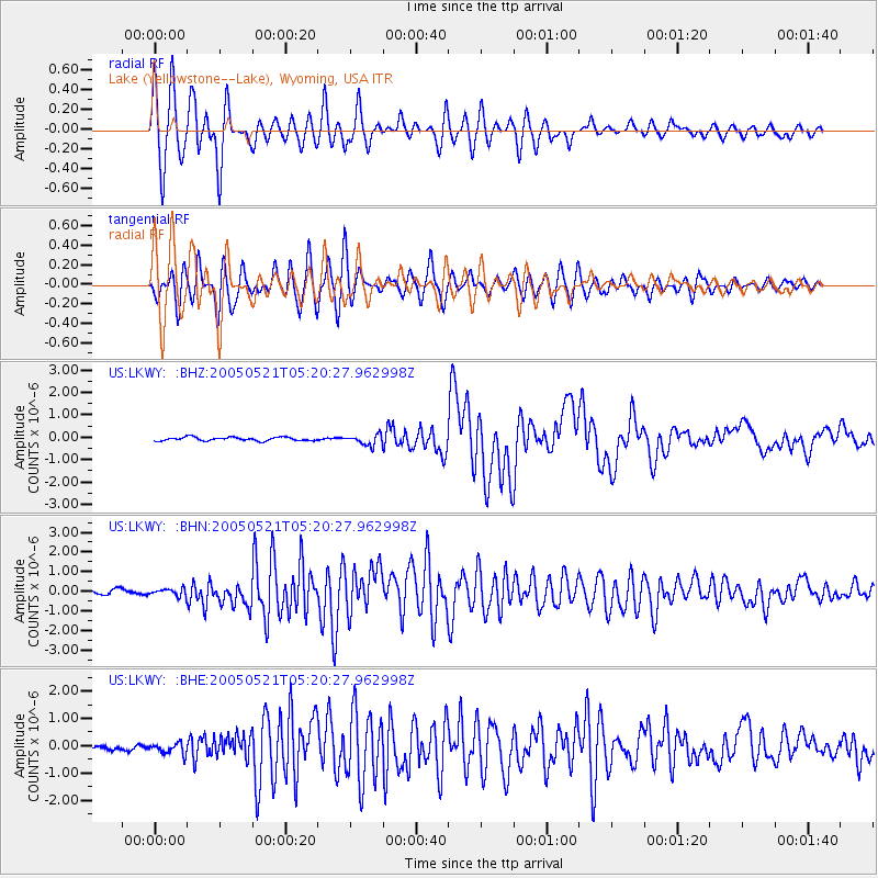
Signal To Noise
| Channel | StoN | STA | LTA |
| US:LKWY: :BHN:20050521T05:20:27.962998Z | 1.367193 | 1.7352927E-7 | 1.2692375E-7 |
| US:LKWY: :BHE:20050521T05:20:27.962998Z | 2.5537891 | 1.9557403E-7 | 7.65819E-8 |
| US:LKWY: :BHZ:20050521T05:20:27.962998Z | 2.9024532 | 2.320538E-7 | 7.9950915E-8 |
| Arrivals |
| Ps | 2.5 SECOND |
| PpPs | 7.5 SECOND |
| PsPs/PpSs | 10 SECOND |


