You are here: Home > Network List > GS - US Geological Survey Networks Stations List
> Station DEC06 Boomer, Decatur, IL, USA > Earthquake Result Viewer
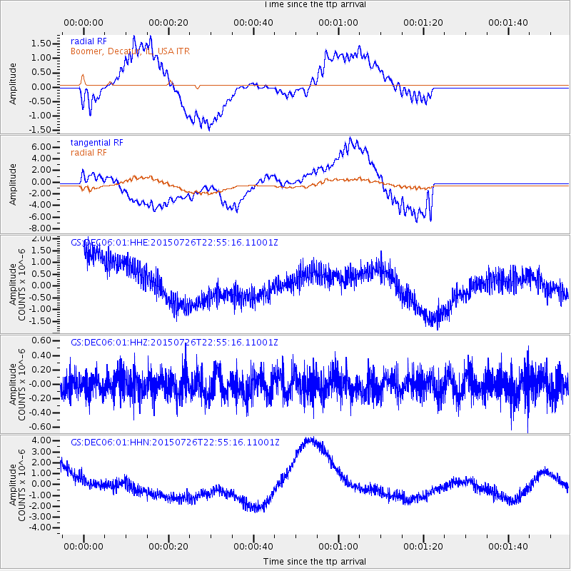
DEC06 Boomer, Decatur, IL, USA - Earthquake Result Viewer
*The percent match for this event was below the threshold and hence no stack was calculated.
| Earthquake location: |
Tonga Islands |
| Earthquake latitude/longitude: |
-18.0/-174.1 |
| Earthquake time(UTC): |
2015/07/26 (207) 22:42:15 GMT |
| Earthquake Depth: |
29 km |
| Earthquake Magnitude: |
5.5 MB |
| Earthquake Catalog/Contributor: |
NEIC PDE/NEIC ALERT |
|
| Network: |
GS US Geological Survey Networks |
| Station: |
DEC06 Boomer, Decatur, IL, USA |
| Lat/Lon: |
39.90 N/88.95 W |
| Elevation: |
215 m |
|
| Distance: |
97.7 deg |
| Az: |
50.671 deg |
| Baz: |
253.081 deg |
| Ray Param: |
$rayparam |
*The percent match for this event was below the threshold and hence was not used in the summary stack. |
|
| Radial Match: |
56.640736 % |
| Radial Bump: |
400 |
| Transverse Match: |
31.221474 % |
| Transverse Bump: |
400 |
| SOD ConfigId: |
1085051 |
| Insert Time: |
2015-08-09 22:55:57.653 +0000 |
| GWidth: |
2.5 |
| Max Bumps: |
400 |
| Tol: |
0.001 |
|
Signal To Noise
| Channel | StoN | STA | LTA |
| GS:DEC06:01:HHZ:20150726T22:55:16.11001Z | 0.8564662 | 1.2904133E-7 | 1.5066715E-7 |
| GS:DEC06:01:HHN:20150726T22:55:16.11001Z | 0.31361052 | 9.1760154E-7 | 2.9259272E-6 |
| GS:DEC06:01:HHE:20150726T22:55:16.11001Z | 1.0668492 | 8.8699545E-7 | 8.3141595E-7 |
| Arrivals |
| Ps | |
| PpPs | |
| PsPs/PpSs | |


