You are here: Home > Network List > AK - Alaska Regional Network Stations List
> Station TABL Table Mountain, AK, USA > Earthquake Result Viewer
TABL Table Mountain, AK, USA - Earthquake Result Viewer
| Earthquake location: |
Vanuatu Islands |
| Earthquake latitude/longitude: |
-14.1/166.6 |
| Earthquake time(UTC): |
2016/04/06 (097) 06:58:48 GMT |
| Earthquake Depth: |
24 km |
| Earthquake Magnitude: |
6.7 MWW, 6.6 MWB, 6.7 MWC, 6.9 MI |
| Earthquake Catalog/Contributor: |
NEIC PDE/NEIC COMCAT |
|
| Network: |
AK Alaska Regional Network |
| Station: |
TABL Table Mountain, AK, USA |
| Lat/Lon: |
60.44 N/141.14 W |
| Elevation: |
2050 m |
|
| Distance: |
85.2 deg |
| Az: |
23.173 deg |
| Baz: |
230.36 deg |
| Ray Param: |
0.044945687 |
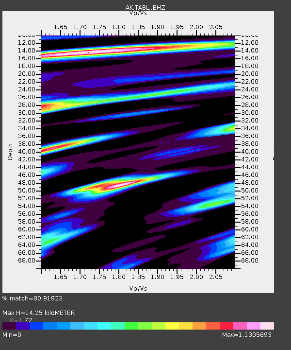
| Estimated Moho Depth: |
14.25 km |
| Estimated Crust Vp/Vs: |
1.72 |
| Assumed Crust Vp: |
6.566 km/s |
| Estimated Crust Vs: |
3.818 km/s |
| Estimated Crust Poisson's Ratio: |
0.24 |
|
| Radial Match: |
80.91923 % |
| Radial Bump: |
400 |
| Transverse Match: |
65.818825 % |
| Transverse Bump: |
400 |
| SOD ConfigId: |
7422571 |
| Insert Time: |
2019-04-22 03:51:44.681 +0000 |
| GWidth: |
2.5 |
| Max Bumps: |
400 |
| Tol: |
0.001 |
|

Signal To Noise
| Channel | StoN | STA | LTA |
| AK:TABL: :BHZ:20160406T07:10:50.748027Z | 10.460898 | 2.2904824E-6 | 2.1895656E-7 |
| AK:TABL: :BHN:20160406T07:10:50.748027Z | 2.7367682 | 6.3969287E-7 | 2.3374024E-7 |
| AK:TABL: :BHE:20160406T07:10:50.748027Z | 1.2830472 | 5.1974956E-7 | 4.0509E-7 |
| Arrivals |
| Ps | 1.6 SECOND |
| PpPs | 5.8 SECOND |
| PsPs/PpSs | 7.4 SECOND |


