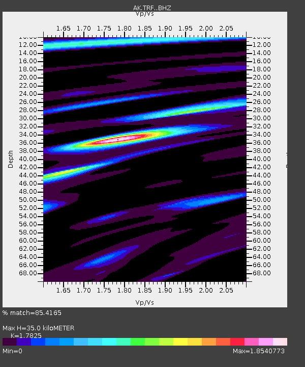
TRF Thorofare Mountian - Earthquake Result Viewer

Earthquake location: Vanuatu Islands
Earthquake latitude/longitude: -14.1/166.6
Earthquake time(UTC): 2016/04/06 (097) 06:58:48 GMT
Earthquake Depth: 24 km
Earthquake Magnitude: 6.7 MWW, 6.6 MWB, 6.7 MWC, 6.9 MI
Earthquake Catalog/Contributor: NEIC PDE/NEIC COMCAT
Network: AK Alaska Regional Network
Station: TRF Thorofare Mountian
Lat/Lon: 63.45 N/150.29 W
Elevation: 1717 m
Distance: 84.1 deg
Az: 17.984 deg
Baz: 221.811 deg
Ray Param: 0.045675565
Estimated Moho Depth: 35.0 km
Estimated Crust Vp/Vs: 1.78
Assumed Crust Vp: 6.438 km/s
Estimated Crust Vs: 3.612 km/s
Estimated Crust Poisson's Ratio: 0.27
Radial Match: 85.4165 %
Radial Bump: 400
Transverse Match: 78.91442 %
Transverse Bump: 400
SOD ConfigId: 7422571
Insert Time: 2019-04-22 03:51:47.173 +0000
GWidth: 2.5
Max Bumps: 400
Tol: 0.001

Signal To Noise

ChannelStoNSTALTA
AK:TRF: :BHZ:20160406T07:10:45.608013Z14.0136562.7623432E-61.9711796E-7
AK:TRF: :BHN:20160406T07:10:45.608013Z3.22948487.0938523E-72.1965894E-7
AK:TRF: :BHE:20160406T07:10:45.608013Z2.4127496.154581E-72.5508584E-7
Arrivals
Ps4.4 SECOND
PpPs15 SECOND
PsPs/PpSs19 SECOND