You are here: Home > Network List > AV - Alaska Volcano Observatory Stations List
> Station SPCR Ckakachatna River, Mount Spurr, Alaska > Earthquake Result Viewer
SPCR Ckakachatna River, Mount Spurr, Alaska - Earthquake Result Viewer
| Earthquake location: |
Vanuatu Islands |
| Earthquake latitude/longitude: |
-14.1/166.6 |
| Earthquake time(UTC): |
2016/04/06 (097) 06:58:48 GMT |
| Earthquake Depth: |
24 km |
| Earthquake Magnitude: |
6.7 MWW, 6.6 MWB, 6.7 MWC, 6.9 MI |
| Earthquake Catalog/Contributor: |
NEIC PDE/NEIC COMCAT |
|
| Network: |
AV Alaska Volcano Observatory |
| Station: |
SPCR Ckakachatna River, Mount Spurr, Alaska |
| Lat/Lon: |
61.20 N/152.21 W |
| Elevation: |
984 m |
|
| Distance: |
81.8 deg |
| Az: |
18.795 deg |
| Baz: |
220.211 deg |
| Ray Param: |
0.04728173 |
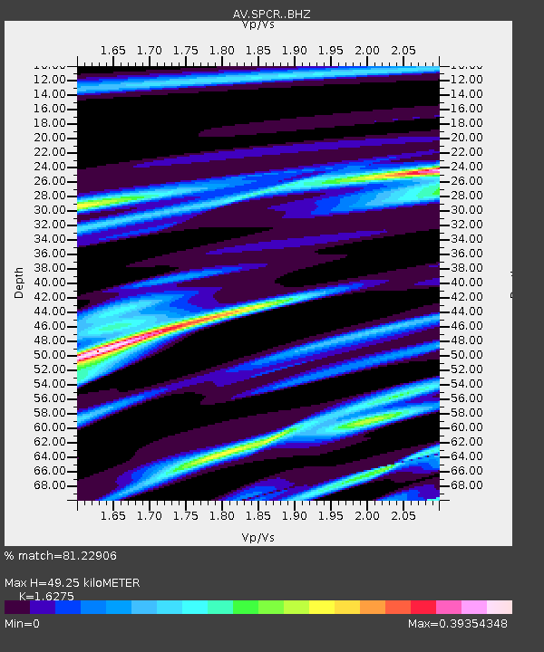
| Estimated Moho Depth: |
49.25 km |
| Estimated Crust Vp/Vs: |
1.63 |
| Assumed Crust Vp: |
6.566 km/s |
| Estimated Crust Vs: |
4.035 km/s |
| Estimated Crust Poisson's Ratio: |
0.20 |
|
| Radial Match: |
81.22906 % |
| Radial Bump: |
400 |
| Transverse Match: |
79.72746 % |
| Transverse Bump: |
400 |
| SOD ConfigId: |
7422571 |
| Insert Time: |
2019-04-22 03:52:26.097 +0000 |
| GWidth: |
2.5 |
| Max Bumps: |
400 |
| Tol: |
0.001 |
|
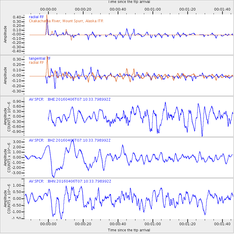
Signal To Noise
| Channel | StoN | STA | LTA |
| AV:SPCR: :BHZ:20160406T07:10:33.798992Z | 12.723817 | 2.5826675E-6 | 2.0297901E-7 |
| AV:SPCR: :BHN:20160406T07:10:33.798992Z | 2.9216945 | 7.785066E-7 | 2.6645722E-7 |
| AV:SPCR: :BHE:20160406T07:10:33.798992Z | 1.1604091 | 2.8911074E-7 | 2.4914553E-7 |
| Arrivals |
| Ps | 4.9 SECOND |
| PpPs | 19 SECOND |
| PsPs/PpSs | 24 SECOND |


