You are here: Home > Network List > IU - Global Seismograph Network (GSN - IRIS/USGS) Stations List
> Station PMG Port Moresby, New Guinea > Earthquake Result Viewer
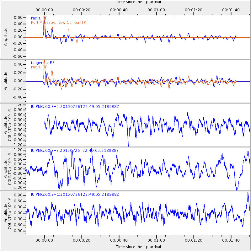
PMG Port Moresby, New Guinea - Earthquake Result Viewer
*The percent match for this event was below the threshold and hence no stack was calculated.
| Earthquake location: |
Tonga Islands |
| Earthquake latitude/longitude: |
-18.0/-174.1 |
| Earthquake time(UTC): |
2015/07/26 (207) 22:42:15 GMT |
| Earthquake Depth: |
29 km |
| Earthquake Magnitude: |
5.5 MB |
| Earthquake Catalog/Contributor: |
NEIC PDE/NEIC ALERT |
|
| Network: |
IU Global Seismograph Network (GSN - IRIS/USGS) |
| Station: |
PMG Port Moresby, New Guinea |
| Lat/Lon: |
9.40 S/147.16 E |
| Elevation: |
90 m |
|
| Distance: |
38.6 deg |
| Az: |
277.572 deg |
| Baz: |
107.08 deg |
| Ray Param: |
$rayparam |
*The percent match for this event was below the threshold and hence was not used in the summary stack. |
|
| Radial Match: |
63.87041 % |
| Radial Bump: |
400 |
| Transverse Match: |
57.976227 % |
| Transverse Bump: |
400 |
| SOD ConfigId: |
1085051 |
| Insert Time: |
2015-08-09 22:57:34.063 +0000 |
| GWidth: |
2.5 |
| Max Bumps: |
400 |
| Tol: |
0.001 |
|
Signal To Noise
| Channel | StoN | STA | LTA |
| IU:PMG:00:BHZ:20150726T22:49:05.218988Z | 3.8360713 | 5.7294613E-7 | 1.4935753E-7 |
| IU:PMG:00:BH1:20150726T22:49:05.218988Z | 1.2347924 | 2.4535385E-7 | 1.9870049E-7 |
| IU:PMG:00:BH2:20150726T22:49:05.218988Z | 1.4143199 | 3.250084E-7 | 2.2979835E-7 |
| Arrivals |
| Ps | |
| PpPs | |
| PsPs/PpSs | |


