You are here: Home > Network List > US - United States National Seismic Network Stations List
> Station AMTX Amarillo, Texas, USA > Earthquake Result Viewer
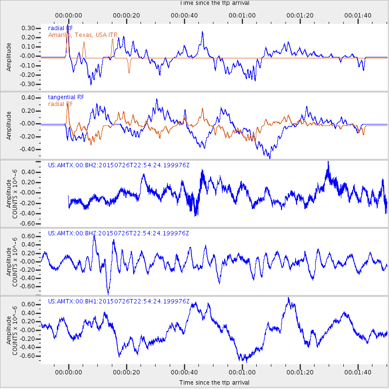
AMTX Amarillo, Texas, USA - Earthquake Result Viewer
*The percent match for this event was below the threshold and hence no stack was calculated.
| Earthquake location: |
Tonga Islands |
| Earthquake latitude/longitude: |
-18.0/-174.1 |
| Earthquake time(UTC): |
2015/07/26 (207) 22:42:15 GMT |
| Earthquake Depth: |
29 km |
| Earthquake Magnitude: |
5.5 MB |
| Earthquake Catalog/Contributor: |
NEIC PDE/NEIC ALERT |
|
| Network: |
US United States National Seismic Network |
| Station: |
AMTX Amarillo, Texas, USA |
| Lat/Lon: |
34.53 N/101.41 W |
| Elevation: |
1010 m |
|
| Distance: |
86.5 deg |
| Az: |
52.14 deg |
| Baz: |
245.494 deg |
| Ray Param: |
$rayparam |
*The percent match for this event was below the threshold and hence was not used in the summary stack. |
|
| Radial Match: |
59.902493 % |
| Radial Bump: |
400 |
| Transverse Match: |
25.169052 % |
| Transverse Bump: |
400 |
| SOD ConfigId: |
1085051 |
| Insert Time: |
2015-08-09 22:59:28.367 +0000 |
| GWidth: |
2.5 |
| Max Bumps: |
400 |
| Tol: |
0.001 |
|
Signal To Noise
| Channel | StoN | STA | LTA |
| US:AMTX:00:BHZ:20150726T22:54:24.199976Z | 1.0181512 | 1.11256014E-7 | 1.0927259E-7 |
| US:AMTX:00:BH1:20150726T22:54:24.199976Z | 2.4038792 | 2.2002794E-7 | 9.153036E-8 |
| US:AMTX:00:BH2:20150726T22:54:24.199976Z | 1.476246 | 1.3860998E-7 | 9.389355E-8 |
| Arrivals |
| Ps | |
| PpPs | |
| PsPs/PpSs | |


