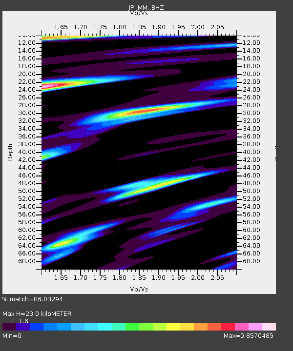
JMM Miyagi Marumori - Earthquake Result Viewer

Earthquake location: Vanuatu Islands
Earthquake latitude/longitude: -14.1/166.6
Earthquake time(UTC): 2016/04/06 (097) 06:58:48 GMT
Earthquake Depth: 24 km
Earthquake Magnitude: 6.7 MWW, 6.6 MWB, 6.7 MWC, 6.9 MI
Earthquake Catalog/Contributor: NEIC PDE/NEIC COMCAT
Network: JP Japan Meteorological Agency Seismic Network
Station: JMM Miyagi Marumori
Lat/Lon: 37.87 N/140.79 E
Elevation: 100 m
Distance: 57.1 deg
Az: 335.765 deg
Baz: 149.783 deg
Ray Param: 0.06368939
Estimated Moho Depth: 23.0 km
Estimated Crust Vp/Vs: 1.60
Assumed Crust Vp: 6.24 km/s
Estimated Crust Vs: 3.9 km/s
Estimated Crust Poisson's Ratio: 0.18
Radial Match: 86.03294 %
Radial Bump: 400
Transverse Match: 77.297356 %
Transverse Bump: 400
SOD ConfigId: 7422571
Insert Time: 2019-04-22 03:55:19.487 +0000
GWidth: 2.5
Max Bumps: 400
Tol: 0.001

Signal To Noise

ChannelStoNSTALTA
JP:JMM: :BHZ:20160406T07:08:01.400005Z19.275415.4101065E-62.8067402E-7
JP:JMM: :BHN:20160406T07:08:01.400005Z6.0077312.0894374E-63.4779146E-7
JP:JMM: :BHE:20160406T07:08:01.400005Z2.97908521.7615765E-65.913146E-7
Arrivals
Ps2.3 SECOND
PpPs9.1 SECOND
PsPs/PpSs11 SECOND