You are here: Home > Network List > NN - Western Great Basin/Eastern Sierra Nevada Stations List
> Station RUB Rubicon Trail, California w84 > Earthquake Result Viewer
RUB Rubicon Trail, California w84 - Earthquake Result Viewer
| Earthquake location: |
Vanuatu Islands |
| Earthquake latitude/longitude: |
-14.1/166.6 |
| Earthquake time(UTC): |
2016/04/06 (097) 06:58:48 GMT |
| Earthquake Depth: |
24 km |
| Earthquake Magnitude: |
6.7 MWW, 6.6 MWB, 6.7 MWC, 6.9 MI |
| Earthquake Catalog/Contributor: |
NEIC PDE/NEIC COMCAT |
|
| Network: |
NN Western Great Basin/Eastern Sierra Nevada |
| Station: |
RUB Rubicon Trail, California w84 |
| Lat/Lon: |
39.05 N/120.15 W |
| Elevation: |
2045 m |
|
| Distance: |
86.2 deg |
| Az: |
48.351 deg |
| Baz: |
248.62 deg |
| Ray Param: |
0.044188023 |
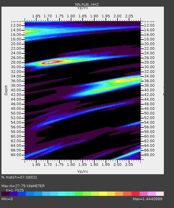
| Estimated Moho Depth: |
27.75 km |
| Estimated Crust Vp/Vs: |
1.70 |
| Assumed Crust Vp: |
6.597 km/s |
| Estimated Crust Vs: |
3.875 km/s |
| Estimated Crust Poisson's Ratio: |
0.24 |
|
| Radial Match: |
87.06821 % |
| Radial Bump: |
400 |
| Transverse Match: |
74.30394 % |
| Transverse Bump: |
400 |
| SOD ConfigId: |
7422571 |
| Insert Time: |
2019-04-22 03:56:00.644 +0000 |
| GWidth: |
2.5 |
| Max Bumps: |
400 |
| Tol: |
0.001 |
|

Signal To Noise
| Channel | StoN | STA | LTA |
| NN:RUB: :HHZ:20160406T07:10:55.970012Z | 6.1116934 | 1.868864E-6 | 3.05785E-7 |
| NN:RUB: :HHN:20160406T07:10:55.970012Z | 0.88264775 | 3.4845544E-7 | 3.9478425E-7 |
| NN:RUB: :HHE:20160406T07:10:55.970012Z | 1.7663816 | 6.334262E-7 | 3.5860103E-7 |
| Arrivals |
| Ps | 3.0 SECOND |
| PpPs | 11 SECOND |
| PsPs/PpSs | 14 SECOND |


