You are here: Home > Network List > S - Seismographs in Schools Projects Stations List
> Station AUCAS Cummins Area School, SA > Earthquake Result Viewer
AUCAS Cummins Area School, SA - Earthquake Result Viewer
| Earthquake location: |
Vanuatu Islands |
| Earthquake latitude/longitude: |
-14.1/166.6 |
| Earthquake time(UTC): |
2016/04/06 (097) 06:58:48 GMT |
| Earthquake Depth: |
24 km |
| Earthquake Magnitude: |
6.7 MWW, 6.6 MWB, 6.7 MWC, 6.9 MI |
| Earthquake Catalog/Contributor: |
NEIC PDE/NEIC COMCAT |
|
| Network: |
S Seismographs in Schools Projects |
| Station: |
AUCAS Cummins Area School, SA |
| Lat/Lon: |
34.26 S/135.72 E |
| Elevation: |
72 m |
|
| Distance: |
34.4 deg |
| Az: |
228.812 deg |
| Baz: |
61.847 deg |
| Ray Param: |
0.07773345 |
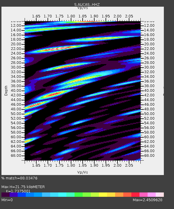
| Estimated Moho Depth: |
21.75 km |
| Estimated Crust Vp/Vs: |
1.74 |
| Assumed Crust Vp: |
6.134 km/s |
| Estimated Crust Vs: |
3.53 km/s |
| Estimated Crust Poisson's Ratio: |
0.25 |
|
| Radial Match: |
88.03476 % |
| Radial Bump: |
400 |
| Transverse Match: |
75.52064 % |
| Transverse Bump: |
400 |
| SOD ConfigId: |
7422571 |
| Insert Time: |
2019-04-22 03:56:40.478 +0000 |
| GWidth: |
2.5 |
| Max Bumps: |
400 |
| Tol: |
0.001 |
|

Signal To Noise
| Channel | StoN | STA | LTA |
| S:AUCAS: :HHZ:20160406T07:05:02.970012Z | 5.3203745 | 4.866919E-6 | 9.1477E-7 |
| S:AUCAS: :HHN:20160406T07:05:02.970012Z | 3.037966 | 3.5077676E-6 | 1.1546434E-6 |
| S:AUCAS: :HHE:20160406T07:05:02.970012Z | 6.532668 | 5.732829E-6 | 8.775632E-7 |
| Arrivals |
| Ps | 2.8 SECOND |
| PpPs | 9.0 SECOND |
| PsPs/PpSs | 12 SECOND |


