You are here: Home > Network List > TA - USArray Transportable Network (new EarthScope stations) Stations List
> Station A04D Lummi Island, WA, USA > Earthquake Result Viewer
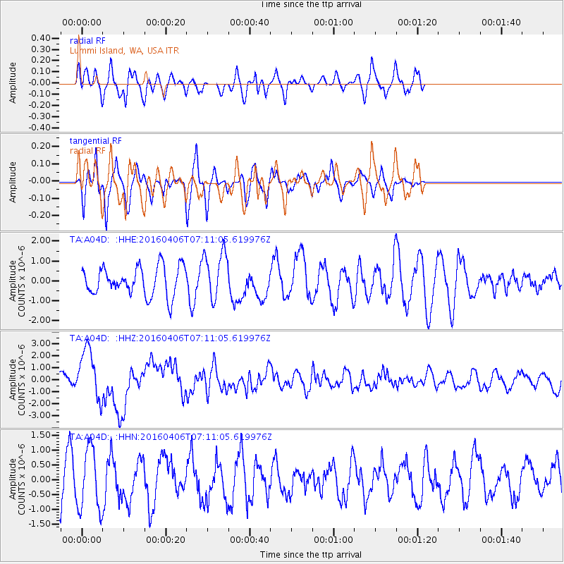
A04D Lummi Island, WA, USA - Earthquake Result Viewer
*The percent match for this event was below the threshold and hence no stack was calculated.
| Earthquake location: |
Vanuatu Islands |
| Earthquake latitude/longitude: |
-14.1/166.6 |
| Earthquake time(UTC): |
2016/04/06 (097) 06:58:48 GMT |
| Earthquake Depth: |
24 km |
| Earthquake Magnitude: |
6.7 MWW, 6.6 MWB, 6.7 MWC, 6.9 MI |
| Earthquake Catalog/Contributor: |
NEIC PDE/NEIC COMCAT |
|
| Network: |
TA USArray Transportable Network (new EarthScope stations) |
| Station: |
A04D Lummi Island, WA, USA |
| Lat/Lon: |
48.72 N/122.71 W |
| Elevation: |
13 m |
|
| Distance: |
88.2 deg |
| Az: |
38.705 deg |
| Baz: |
246.38 deg |
| Ray Param: |
$rayparam |
*The percent match for this event was below the threshold and hence was not used in the summary stack. |
|
| Radial Match: |
55.891937 % |
| Radial Bump: |
389 |
| Transverse Match: |
60.18674 % |
| Transverse Bump: |
326 |
| SOD ConfigId: |
7422571 |
| Insert Time: |
2019-04-22 03:56:48.783 +0000 |
| GWidth: |
2.5 |
| Max Bumps: |
400 |
| Tol: |
0.001 |
|
Signal To Noise
| Channel | StoN | STA | LTA |
| TA:A04D: :HHZ:20160406T07:11:05.619976Z | 2.9213471 | 2.1648464E-6 | 7.4104383E-7 |
| TA:A04D: :HHN:20160406T07:11:05.619976Z | 1.4798006 | 1.0624791E-6 | 7.17988E-7 |
| TA:A04D: :HHE:20160406T07:11:05.619976Z | 1.5597017 | 1.1153577E-6 | 7.1510965E-7 |
| Arrivals |
| Ps | |
| PpPs | |
| PsPs/PpSs | |


