You are here: Home > Network List > TA - USArray Transportable Network (new EarthScope stations) Stations List
> Station A21K Barrow, AK, USA > Earthquake Result Viewer
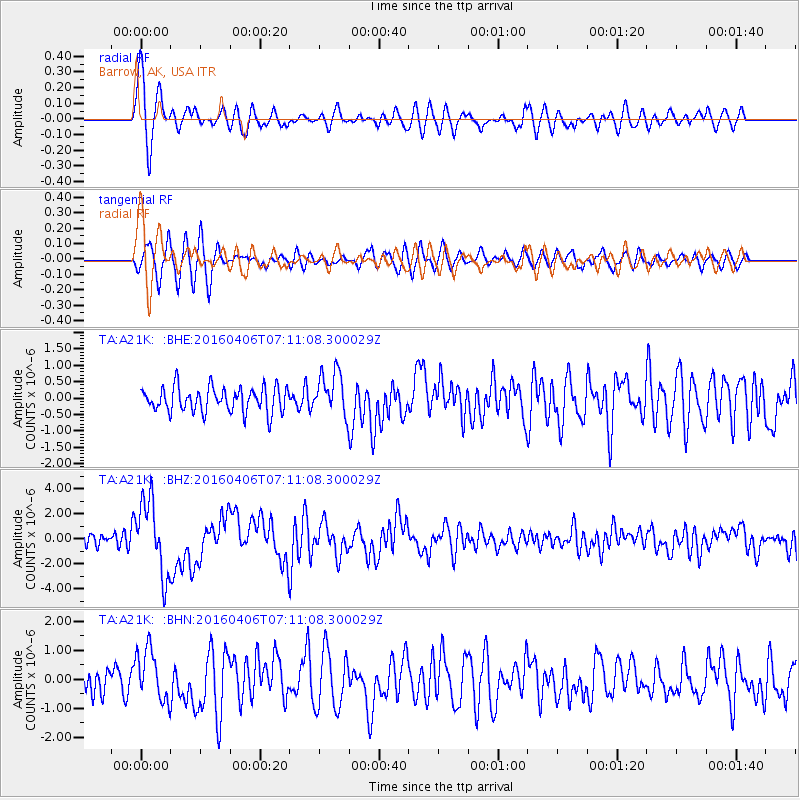
A21K Barrow, AK, USA - Earthquake Result Viewer
*The percent match for this event was below the threshold and hence no stack was calculated.
| Earthquake location: |
Vanuatu Islands |
| Earthquake latitude/longitude: |
-14.1/166.6 |
| Earthquake time(UTC): |
2016/04/06 (097) 06:58:48 GMT |
| Earthquake Depth: |
24 km |
| Earthquake Magnitude: |
6.7 MWW, 6.6 MWB, 6.7 MWC, 6.9 MI |
| Earthquake Catalog/Contributor: |
NEIC PDE/NEIC COMCAT |
|
| Network: |
TA USArray Transportable Network (new EarthScope stations) |
| Station: |
A21K Barrow, AK, USA |
| Lat/Lon: |
71.32 N/156.62 W |
| Elevation: |
577 m |
|
| Distance: |
88.8 deg |
| Az: |
11.126 deg |
| Baz: |
215.533 deg |
| Ray Param: |
$rayparam |
*The percent match for this event was below the threshold and hence was not used in the summary stack. |
|
| Radial Match: |
77.725464 % |
| Radial Bump: |
400 |
| Transverse Match: |
61.109936 % |
| Transverse Bump: |
400 |
| SOD ConfigId: |
7422571 |
| Insert Time: |
2019-04-22 03:56:51.246 +0000 |
| GWidth: |
2.5 |
| Max Bumps: |
400 |
| Tol: |
0.001 |
|
Signal To Noise
| Channel | StoN | STA | LTA |
| TA:A21K: :BHZ:20160406T07:11:08.300029Z | 4.369163 | 2.9315995E-6 | 6.709751E-7 |
| TA:A21K: :BHN:20160406T07:11:08.300029Z | 2.1203783 | 8.8305404E-7 | 4.1646064E-7 |
| TA:A21K: :BHE:20160406T07:11:08.300029Z | 2.1293278 | 7.952868E-7 | 3.7349196E-7 |
| Arrivals |
| Ps | |
| PpPs | |
| PsPs/PpSs | |


