You are here: Home > Network List > US - United States National Seismic Network Stations List
> Station LKWY Lake (Yellowstone--Lake), Wyoming, USA > Earthquake Result Viewer
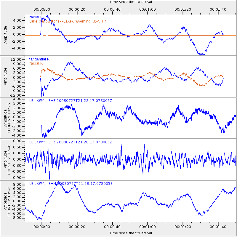
LKWY Lake (Yellowstone--Lake), Wyoming, USA - Earthquake Result Viewer
*The percent match for this event was below the threshold and hence no stack was calculated.
| Earthquake location: |
Central Mid-Atlantic Ridge |
| Earthquake latitude/longitude: |
-0.3/-18.3 |
| Earthquake time(UTC): |
2008/07/27 (209) 21:15:41 GMT |
| Earthquake Depth: |
10 km |
| Earthquake Magnitude: |
5.8 MB, 5.3 MS, 5.9 MW, 5.8 MW |
| Earthquake Catalog/Contributor: |
WHDF/NEIC |
|
| Network: |
US United States National Seismic Network |
| Station: |
LKWY Lake (Yellowstone--Lake), Wyoming, USA |
| Lat/Lon: |
44.57 N/110.40 W |
| Elevation: |
2424 m |
|
| Distance: |
91.7 deg |
| Az: |
314.387 deg |
| Baz: |
88.713 deg |
| Ray Param: |
$rayparam |
*The percent match for this event was below the threshold and hence was not used in the summary stack. |
|
| Radial Match: |
67.000084 % |
| Radial Bump: |
400 |
| Transverse Match: |
44.901672 % |
| Transverse Bump: |
400 |
| SOD ConfigId: |
2504 |
| Insert Time: |
2010-03-05 00:58:39.239 +0000 |
| GWidth: |
2.5 |
| Max Bumps: |
400 |
| Tol: |
0.001 |
|
Signal To Noise
| Channel | StoN | STA | LTA |
| US:LKWY: :BHZ:20080727T21:28:17.078005Z | 2.3512115 | 3.7724365E-7 | 1.604465E-7 |
| US:LKWY: :BHN:20080727T21:28:17.078005Z | 1.569176 | 4.6925506E-6 | 2.9904554E-6 |
| US:LKWY: :BHE:20080727T21:28:17.078005Z | 0.57474095 | 1.3703782E-6 | 2.3843406E-6 |
| Arrivals |
| Ps | |
| PpPs | |
| PsPs/PpSs | |


