You are here: Home > Network List > TA - USArray Transportable Network (new EarthScope stations) Stations List
> Station L20K Farewell, AK, USA > Earthquake Result Viewer
L20K Farewell, AK, USA - Earthquake Result Viewer
| Earthquake location: |
Vanuatu Islands |
| Earthquake latitude/longitude: |
-14.1/166.6 |
| Earthquake time(UTC): |
2016/04/06 (097) 06:58:48 GMT |
| Earthquake Depth: |
24 km |
| Earthquake Magnitude: |
6.7 MWW, 6.6 MWB, 6.7 MWC, 6.9 MI |
| Earthquake Catalog/Contributor: |
NEIC PDE/NEIC COMCAT |
|
| Network: |
TA USArray Transportable Network (new EarthScope stations) |
| Station: |
L20K Farewell, AK, USA |
| Lat/Lon: |
62.48 N/153.88 W |
| Elevation: |
673 m |
|
| Distance: |
82.3 deg |
| Az: |
17.355 deg |
| Baz: |
218.541 deg |
| Ray Param: |
0.046940953 |
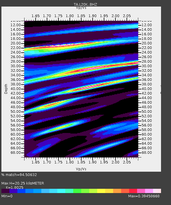
| Estimated Moho Depth: |
20.25 km |
| Estimated Crust Vp/Vs: |
1.80 |
| Assumed Crust Vp: |
6.566 km/s |
| Estimated Crust Vs: |
3.643 km/s |
| Estimated Crust Poisson's Ratio: |
0.28 |
|
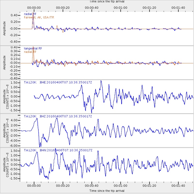
| Radial Match: |
94.50632 % |
| Radial Bump: |
295 |
| Transverse Match: |
84.18013 % |
| Transverse Bump: |
400 |
| SOD ConfigId: |
7422571 |
| Insert Time: |
2019-04-22 03:57:23.056 +0000 |
| GWidth: |
2.5 |
| Max Bumps: |
400 |
| Tol: |
0.001 |
|
Signal To Noise
| Channel | StoN | STA | LTA |
| TA:L20K: :BHZ:20160406T07:10:36.350017Z | 23.556198 | 4.0363266E-6 | 1.7134882E-7 |
| TA:L20K: :BHN:20160406T07:10:36.350017Z | 6.001735 | 8.6839395E-7 | 1.4469047E-7 |
| TA:L20K: :BHE:20160406T07:10:36.350017Z | 4.978686 | 7.5438305E-7 | 1.5152253E-7 |
| Arrivals |
| Ps | 2.5 SECOND |
| PpPs | 8.4 SECOND |
| PsPs/PpSs | 11 SECOND |


