You are here: Home > Network List > TA - USArray Transportable Network (new EarthScope stations) Stations List
> Station O02D Mt. Diablo Meridian, CA, USA > Earthquake Result Viewer
O02D Mt. Diablo Meridian, CA, USA - Earthquake Result Viewer

| Earthquake location: |
Vanuatu Islands |
| Earthquake latitude/longitude: |
-14.1/166.6 |
| Earthquake time(UTC): |
2016/04/06 (097) 06:58:48 GMT |
| Earthquake Depth: |
24 km |
| Earthquake Magnitude: |
6.7 MWW, 6.6 MWB, 6.7 MWC, 6.9 MI |
| Earthquake Catalog/Contributor: |
NEIC PDE/NEIC COMCAT |
|
| Network: |
TA USArray Transportable Network (new EarthScope stations) |
| Station: |
O02D Mt. Diablo Meridian, CA, USA |
| Lat/Lon: |
40.18 N/122.79 W |
| Elevation: |
965 m |
|
| Distance: |
84.8 deg |
| Az: |
46.534 deg |
| Baz: |
246.804 deg |
| Ray Param: |
0.045229495 |
| Estimated Moho Depth: |
22.0 km |
| Estimated Crust Vp/Vs: |
1.60 |
| Assumed Crust Vp: |
6.566 km/s |
| Estimated Crust Vs: |
4.104 km/s |
| Estimated Crust Poisson's Ratio: |
0.18 |
|
| Radial Match: |
83.02482 % |
| Radial Bump: |
400 |
| Transverse Match: |
69.66379 % |
| Transverse Bump: |
400 |
| SOD ConfigId: |
7422571 |
| Insert Time: |
2019-04-22 03:57:37.115 +0000 |
| GWidth: |
2.5 |
| Max Bumps: |
400 |
| Tol: |
0.001 |
|
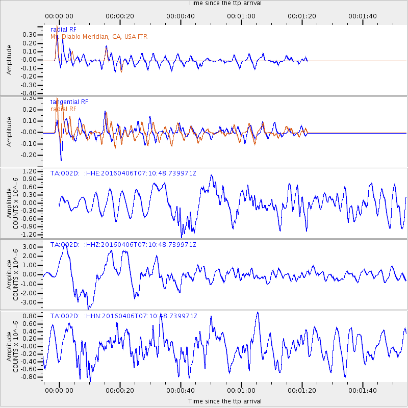
Signal To Noise
| Channel | StoN | STA | LTA |
| TA:O02D: :HHZ:20160406T07:10:48.739971Z | 9.067736 | 2.05756E-6 | 2.2691E-7 |
| TA:O02D: :HHN:20160406T07:10:48.739971Z | 1.7792356 | 3.9060737E-7 | 2.1953662E-7 |
| TA:O02D: :HHE:20160406T07:10:48.739971Z | 1.9785581 | 6.0846895E-7 | 3.075315E-7 |
| Arrivals |
| Ps | 2.1 SECOND |
| PpPs | 8.5 SECOND |
| PsPs/PpSs | 11 SECOND |


