You are here: Home > Network List > TA - USArray Transportable Network (new EarthScope stations) Stations List
> Station S22A 4UR Ranch, Creede, CO, USA > Earthquake Result Viewer
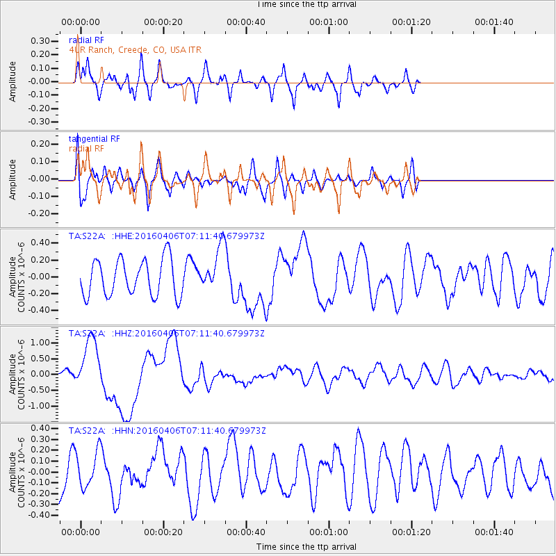
S22A 4UR Ranch, Creede, CO, USA - Earthquake Result Viewer
*The percent match for this event was below the threshold and hence no stack was calculated.
| Earthquake location: |
Vanuatu Islands |
| Earthquake latitude/longitude: |
-14.1/166.6 |
| Earthquake time(UTC): |
2016/04/06 (097) 06:58:48 GMT |
| Earthquake Depth: |
24 km |
| Earthquake Magnitude: |
6.7 MWW, 6.6 MWB, 6.7 MWC, 6.9 MI |
| Earthquake Catalog/Contributor: |
NEIC PDE/NEIC COMCAT |
|
| Network: |
TA USArray Transportable Network (new EarthScope stations) |
| Station: |
S22A 4UR Ranch, Creede, CO, USA |
| Lat/Lon: |
37.75 N/106.83 W |
| Elevation: |
2626 m |
|
| Distance: |
95.8 deg |
| Az: |
52.693 deg |
| Baz: |
256.809 deg |
| Ray Param: |
$rayparam |
*The percent match for this event was below the threshold and hence was not used in the summary stack. |
|
| Radial Match: |
77.24951 % |
| Radial Bump: |
400 |
| Transverse Match: |
51.56606 % |
| Transverse Bump: |
400 |
| SOD ConfigId: |
7422571 |
| Insert Time: |
2019-04-22 03:57:47.843 +0000 |
| GWidth: |
2.5 |
| Max Bumps: |
400 |
| Tol: |
0.001 |
|
Signal To Noise
| Channel | StoN | STA | LTA |
| TA:S22A: :HHZ:20160406T07:11:40.679973Z | 5.525501 | 8.632153E-7 | 1.562239E-7 |
| TA:S22A: :HHN:20160406T07:11:40.679973Z | 1.2404319 | 1.6693475E-7 | 1.3457793E-7 |
| TA:S22A: :HHE:20160406T07:11:40.679973Z | 1.3868392 | 2.9968538E-7 | 2.1609239E-7 |
| Arrivals |
| Ps | |
| PpPs | |
| PsPs/PpSs | |


