You are here: Home > Network List > XD14 - Illuminating the architecture of the greater Mount St. Helens magmatic systems f Stations List
> Station MG07 "Mount St Helens, WA" > Earthquake Result Viewer
MG07 "Mount St Helens, WA" - Earthquake Result Viewer
| Earthquake location: |
Vanuatu Islands |
| Earthquake latitude/longitude: |
-14.1/166.6 |
| Earthquake time(UTC): |
2016/04/06 (097) 06:58:48 GMT |
| Earthquake Depth: |
24 km |
| Earthquake Magnitude: |
6.7 MWW, 6.6 MWB, 6.7 MWC, 6.9 MI |
| Earthquake Catalog/Contributor: |
NEIC PDE/NEIC COMCAT |
|
| Network: |
XD Illuminating the architecture of the greater Mount St. Helens magmatic systems f |
| Station: |
MG07 "Mount St Helens, WA" |
| Lat/Lon: |
46.35 N/122.03 W |
| Elevation: |
1457 m |
|
| Distance: |
87.7 deg |
| Az: |
41.063 deg |
| Baz: |
246.961 deg |
| Ray Param: |
0.04311723 |
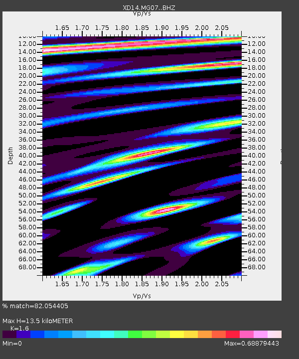
| Estimated Moho Depth: |
13.5 km |
| Estimated Crust Vp/Vs: |
1.60 |
| Assumed Crust Vp: |
6.566 km/s |
| Estimated Crust Vs: |
4.104 km/s |
| Estimated Crust Poisson's Ratio: |
0.18 |
|
| Radial Match: |
82.054405 % |
| Radial Bump: |
400 |
| Transverse Match: |
58.74905 % |
| Transverse Bump: |
400 |
| SOD ConfigId: |
7422571 |
| Insert Time: |
2019-04-22 03:58:58.704 +0000 |
| GWidth: |
2.5 |
| Max Bumps: |
400 |
| Tol: |
0.001 |
|

Signal To Noise
| Channel | StoN | STA | LTA |
| XD:MG07: :BHZ:20160406T07:11:03.145Z | 8.115819 | 1.9033265E-6 | 2.3452057E-7 |
| XD:MG07: :BHN:20160406T07:11:03.145Z | 1.4387442 | 2.1561247E-7 | 1.4986156E-7 |
| XD:MG07: :BHE:20160406T07:11:03.145Z | 3.148456 | 5.049765E-7 | 1.6038862E-7 |
| Arrivals |
| Ps | 1.3 SECOND |
| PpPs | 5.2 SECOND |
| PsPs/PpSs | 6.5 SECOND |


