You are here: Home > Network List > YN10 - San Jacinto Fault Zone Stations List
> Station GVAR1 GVAR1, Anza, CA, USA > Earthquake Result Viewer
GVAR1 GVAR1, Anza, CA, USA - Earthquake Result Viewer
| Earthquake location: |
Vanuatu Islands |
| Earthquake latitude/longitude: |
-14.1/166.6 |
| Earthquake time(UTC): |
2016/04/06 (097) 06:58:48 GMT |
| Earthquake Depth: |
24 km |
| Earthquake Magnitude: |
6.7 MWW, 6.6 MWB, 6.7 MWC, 6.9 MI |
| Earthquake Catalog/Contributor: |
NEIC PDE/NEIC COMCAT |
|
| Network: |
YN San Jacinto Fault Zone |
| Station: |
GVAR1 GVAR1, Anza, CA, USA |
| Lat/Lon: |
33.67 N/116.71 W |
| Elevation: |
1328 m |
|
| Distance: |
87.0 deg |
| Az: |
54.365 deg |
| Baz: |
251.016 deg |
| Ray Param: |
0.043636642 |
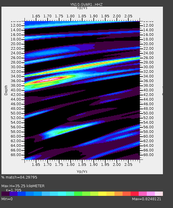
| Estimated Moho Depth: |
35.25 km |
| Estimated Crust Vp/Vs: |
1.71 |
| Assumed Crust Vp: |
6.264 km/s |
| Estimated Crust Vs: |
3.674 km/s |
| Estimated Crust Poisson's Ratio: |
0.24 |
|
| Radial Match: |
84.29795 % |
| Radial Bump: |
373 |
| Transverse Match: |
62.788044 % |
| Transverse Bump: |
400 |
| SOD ConfigId: |
7422571 |
| Insert Time: |
2019-04-22 04:00:33.485 +0000 |
| GWidth: |
2.5 |
| Max Bumps: |
400 |
| Tol: |
0.001 |
|

Signal To Noise
| Channel | StoN | STA | LTA |
| YN:GVAR1: :HHZ:20160406T07:10:59.673992Z | 15.267708 | 1.7430415E-6 | 1.1416523E-7 |
| YN:GVAR1: :HHN:20160406T07:10:59.673992Z | 1.3687906 | 2.0190237E-7 | 1.475042E-7 |
| YN:GVAR1: :HHE:20160406T07:10:59.673992Z | 6.835022 | 7.4012746E-7 | 1.08284574E-7 |
| Arrivals |
| Ps | 4.1 SECOND |
| PpPs | 15 SECOND |
| PsPs/PpSs | 19 SECOND |


