You are here: Home > Network List > TA - USArray Transportable Network (new EarthScope stations) Stations List
> Station J01E Myrtle Point, OR, USA > Earthquake Result Viewer
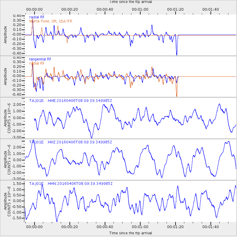
J01E Myrtle Point, OR, USA - Earthquake Result Viewer
*The percent match for this event was below the threshold and hence no stack was calculated.
| Earthquake location: |
Vanuatu Islands |
| Earthquake latitude/longitude: |
-14.2/166.6 |
| Earthquake time(UTC): |
2016/04/06 (097) 07:57:38 GMT |
| Earthquake Depth: |
35 km |
| Earthquake Magnitude: |
5.9 MWW, 6.0 MWC |
| Earthquake Catalog/Contributor: |
NEIC PDE/NEIC COMCAT |
|
| Network: |
TA USArray Transportable Network (new EarthScope stations) |
| Station: |
J01E Myrtle Point, OR, USA |
| Lat/Lon: |
43.16 N/123.93 W |
| Elevation: |
128 m |
|
| Distance: |
85.3 deg |
| Az: |
43.44 deg |
| Baz: |
245.671 deg |
| Ray Param: |
$rayparam |
*The percent match for this event was below the threshold and hence was not used in the summary stack. |
|
| Radial Match: |
77.00689 % |
| Radial Bump: |
400 |
| Transverse Match: |
79.135315 % |
| Transverse Bump: |
400 |
| SOD ConfigId: |
7422571 |
| Insert Time: |
2019-04-22 04:05:06.864 +0000 |
| GWidth: |
2.5 |
| Max Bumps: |
400 |
| Tol: |
0.001 |
|
Signal To Noise
| Channel | StoN | STA | LTA |
| TA:J01E: :HHZ:20160406T08:09:39.349985Z | 1.3266 | 1.7571763E-6 | 1.3245714E-6 |
| TA:J01E: :HHN:20160406T08:09:39.349985Z | 0.8651761 | 7.258778E-7 | 8.3899425E-7 |
| TA:J01E: :HHE:20160406T08:09:39.349985Z | 2.1286373 | 1.96537E-6 | 9.232997E-7 |
| Arrivals |
| Ps | |
| PpPs | |
| PsPs/PpSs | |


