You are here: Home > Network List > UW - Pacific Northwest Regional Seismic Network Stations List
> Station LEBA Lebam, WA, USA > Earthquake Result Viewer
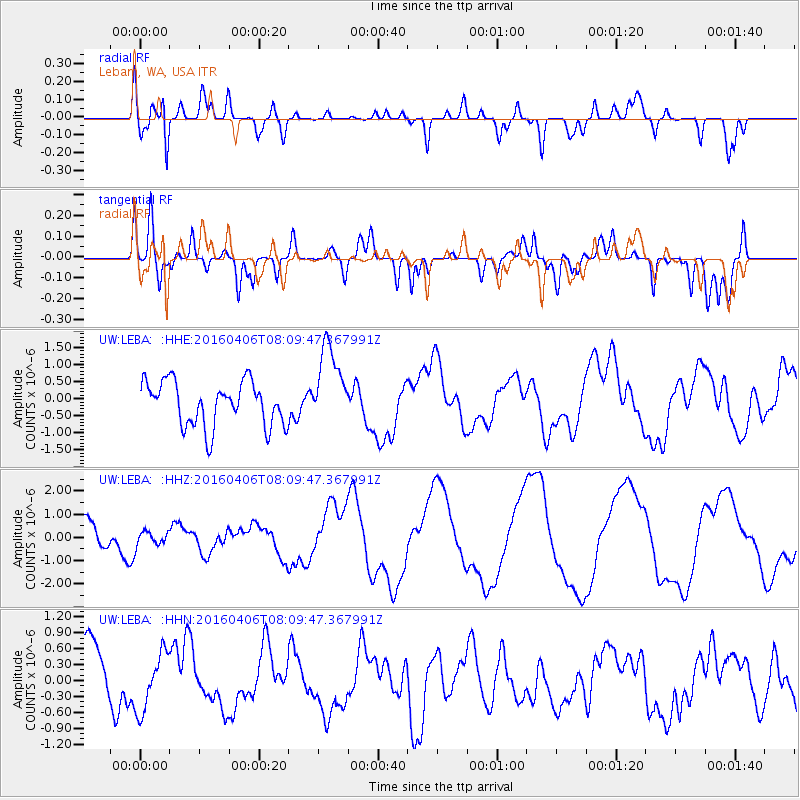
LEBA Lebam, WA, USA - Earthquake Result Viewer
*The percent match for this event was below the threshold and hence no stack was calculated.
| Earthquake location: |
Vanuatu Islands |
| Earthquake latitude/longitude: |
-14.2/166.6 |
| Earthquake time(UTC): |
2016/04/06 (097) 07:57:38 GMT |
| Earthquake Depth: |
35 km |
| Earthquake Magnitude: |
5.9 MWW, 6.0 MWC |
| Earthquake Catalog/Contributor: |
NEIC PDE/NEIC COMCAT |
|
| Network: |
UW Pacific Northwest Regional Seismic Network |
| Station: |
LEBA Lebam, WA, USA |
| Lat/Lon: |
46.55 N/123.56 W |
| Elevation: |
73 m |
|
| Distance: |
86.9 deg |
| Az: |
40.456 deg |
| Baz: |
245.727 deg |
| Ray Param: |
$rayparam |
*The percent match for this event was below the threshold and hence was not used in the summary stack. |
|
| Radial Match: |
77.050026 % |
| Radial Bump: |
400 |
| Transverse Match: |
62.641693 % |
| Transverse Bump: |
400 |
| SOD ConfigId: |
7422571 |
| Insert Time: |
2019-04-22 04:05:54.913 +0000 |
| GWidth: |
2.5 |
| Max Bumps: |
400 |
| Tol: |
0.001 |
|
Signal To Noise
| Channel | StoN | STA | LTA |
| UW:LEBA: :HHZ:20160406T08:09:47.367991Z | 0.5779697 | 2.8571992E-7 | 4.9435107E-7 |
| UW:LEBA: :HHN:20160406T08:09:47.367991Z | 0.687561 | 5.5141504E-7 | 8.0198714E-7 |
| UW:LEBA: :HHE:20160406T08:09:47.367991Z | 1.9544927 | 1.2417611E-6 | 6.353368E-7 |
| Arrivals |
| Ps | |
| PpPs | |
| PsPs/PpSs | |


