You are here: Home > Network List > CB - China National Seismic Network Stations List
> Station LZH Lanzhou,Gansu Province > Earthquake Result Viewer
LZH Lanzhou,Gansu Province - Earthquake Result Viewer
| Earthquake location: |
Java, Indonesia |
| Earthquake latitude/longitude: |
-8.2/107.4 |
| Earthquake time(UTC): |
2016/04/06 (097) 14:45:30 GMT |
| Earthquake Depth: |
35 km |
| Earthquake Magnitude: |
6.0 MWB |
| Earthquake Catalog/Contributor: |
NEIC PDE/NEIC COMCAT |
|
| Network: |
CB China National Seismic Network |
| Station: |
LZH Lanzhou,Gansu Province |
| Lat/Lon: |
36.09 N/103.84 E |
| Elevation: |
1560 m |
|
| Distance: |
44.2 deg |
| Az: |
355.844 deg |
| Baz: |
174.919 deg |
| Ray Param: |
0.07200618 |
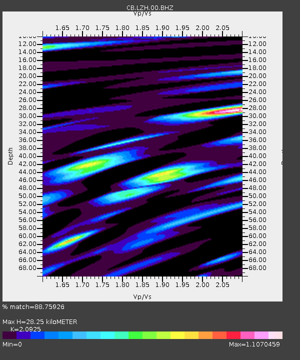
| Estimated Moho Depth: |
28.25 km |
| Estimated Crust Vp/Vs: |
2.09 |
| Assumed Crust Vp: |
6.306 km/s |
| Estimated Crust Vs: |
3.014 km/s |
| Estimated Crust Poisson's Ratio: |
0.35 |
|
| Radial Match: |
88.75926 % |
| Radial Bump: |
370 |
| Transverse Match: |
70.25876 % |
| Transverse Bump: |
400 |
| SOD ConfigId: |
7422571 |
| Insert Time: |
2019-04-22 04:08:20.556 +0000 |
| GWidth: |
2.5 |
| Max Bumps: |
400 |
| Tol: |
0.001 |
|

Signal To Noise
| Channel | StoN | STA | LTA |
| CB:LZH:00:BHZ:20160406T14:53:05.190Z | 7.198458 | 6.8301597E-7 | 9.488365E-8 |
| CB:LZH:00:BHN:20160406T14:53:05.190Z | 2.8196774 | 3.930352E-7 | 1.3939014E-7 |
| CB:LZH:00:BHE:20160406T14:53:05.190Z | 0.9765657 | 1.7131563E-7 | 1.7542663E-7 |
| Arrivals |
| Ps | 5.2 SECOND |
| PpPs | 13 SECOND |
| PsPs/PpSs | 18 SECOND |


