You are here: Home > Network List > KR - Kyrgyz Digital Network Stations List
> Station BTK Batken, Kyrgyzstan > Earthquake Result Viewer
BTK Batken, Kyrgyzstan - Earthquake Result Viewer
| Earthquake location: |
Java, Indonesia |
| Earthquake latitude/longitude: |
-8.2/107.4 |
| Earthquake time(UTC): |
2016/04/06 (097) 14:45:30 GMT |
| Earthquake Depth: |
35 km |
| Earthquake Magnitude: |
6.0 MWB |
| Earthquake Catalog/Contributor: |
NEIC PDE/NEIC COMCAT |
|
| Network: |
KR Kyrgyz Digital Network |
| Station: |
BTK Batken, Kyrgyzstan |
| Lat/Lon: |
40.06 N/70.82 E |
| Elevation: |
980 m |
|
| Distance: |
58.7 deg |
| Az: |
327.63 deg |
| Baz: |
136.327 deg |
| Ray Param: |
0.062593326 |
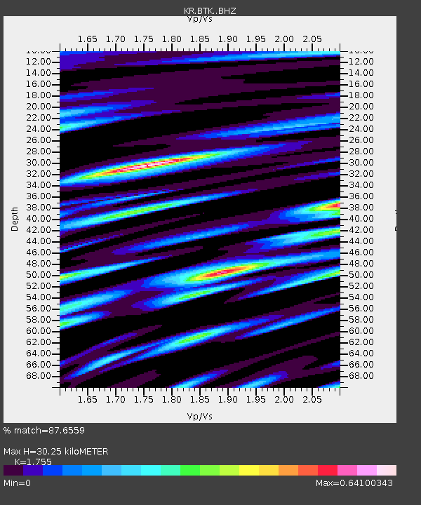
| Estimated Moho Depth: |
30.25 km |
| Estimated Crust Vp/Vs: |
1.75 |
| Assumed Crust Vp: |
6.236 km/s |
| Estimated Crust Vs: |
3.553 km/s |
| Estimated Crust Poisson's Ratio: |
0.26 |
|
| Radial Match: |
87.6559 % |
| Radial Bump: |
400 |
| Transverse Match: |
82.75845 % |
| Transverse Bump: |
400 |
| SOD ConfigId: |
7422571 |
| Insert Time: |
2019-04-22 04:09:42.369 +0000 |
| GWidth: |
2.5 |
| Max Bumps: |
400 |
| Tol: |
0.001 |
|

Signal To Noise
| Channel | StoN | STA | LTA |
| KR:BTK: :BHZ:20160406T14:54:53.749998Z | 16.496237 | 1.0886853E-6 | 6.5995984E-8 |
| KR:BTK: :BHN:20160406T14:54:53.749998Z | 6.270934 | 3.592218E-7 | 5.7283618E-8 |
| KR:BTK: :BHE:20160406T14:54:53.749998Z | 6.3355775 | 2.767046E-7 | 4.3674728E-8 |
| Arrivals |
| Ps | 3.8 SECOND |
| PpPs | 13 SECOND |
| PsPs/PpSs | 17 SECOND |


