You are here: Home > Network List > II - Global Seismograph Network (GSN - IRIS/IDA) Stations List
> Station CMLA Cha de Macela, Sao Miguel Island, Azores > Earthquake Result Viewer
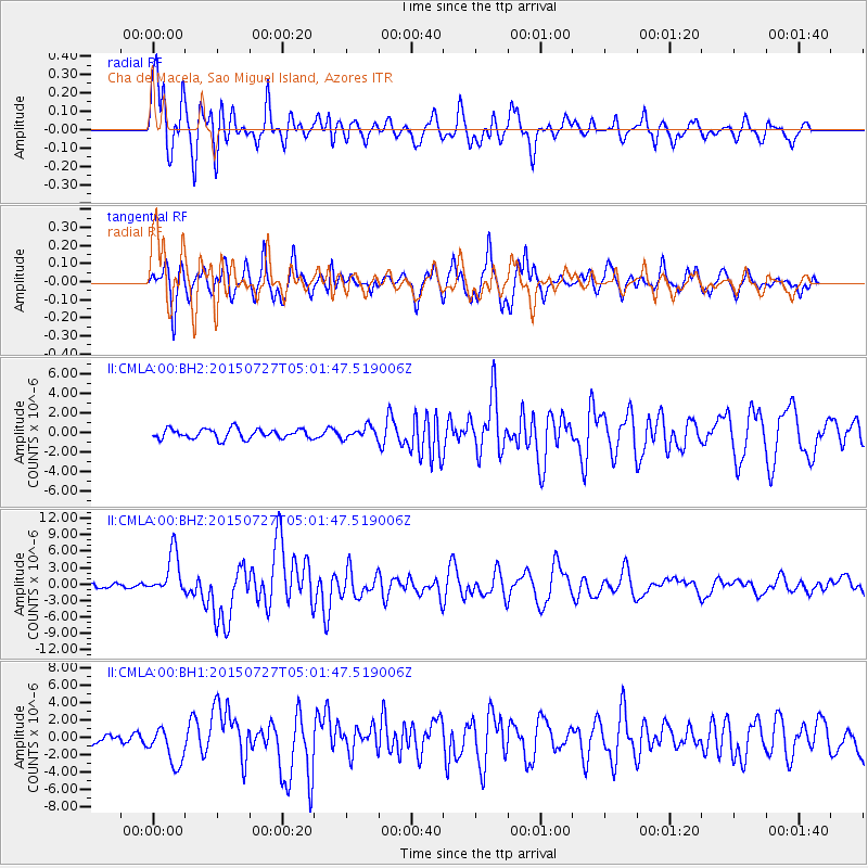
CMLA Cha de Macela, Sao Miguel Island, Azores - Earthquake Result Viewer

| Earthquake location: |
Fox Islands, Aleutian Islands |
| Earthquake latitude/longitude: |
52.4/-169.7 |
| Earthquake time(UTC): |
2015/07/27 (208) 04:49:44 GMT |
| Earthquake Depth: |
12 km |
| Earthquake Magnitude: |
6.9 MO |
| Earthquake Catalog/Contributor: |
NEIC PDE/NEIC ALERT |
|
| Network: |
II Global Seismograph Network (GSN - IRIS/IDA) |
| Station: |
CMLA Cha de Macela, Sao Miguel Island, Azores |
| Lat/Lon: |
37.76 N/25.52 W |
| Elevation: |
429 m |
|
| Distance: |
84.9 deg |
| Az: |
27.785 deg |
| Baz: |
338.864 deg |
| Ray Param: |
0.045113377 |
| Estimated Moho Depth: |
15.0 km |
| Estimated Crust Vp/Vs: |
1.60 |
| Assumed Crust Vp: |
4.802 km/s |
| Estimated Crust Vs: |
3.001 km/s |
| Estimated Crust Poisson's Ratio: |
0.18 |
|
| Radial Match: |
84.92276 % |
| Radial Bump: |
400 |
| Transverse Match: |
75.05222 % |
| Transverse Bump: |
400 |
| SOD ConfigId: |
1085051 |
| Insert Time: |
2015-08-10 05:12:03.859 +0000 |
| GWidth: |
2.5 |
| Max Bumps: |
400 |
| Tol: |
0.001 |
|
Signal To Noise
| Channel | StoN | STA | LTA |
| II:CMLA:00:BHZ:20150727T05:01:47.519006Z | 11.834609 | 3.857887E-6 | 3.2598348E-7 |
| II:CMLA:00:BH1:20150727T05:01:47.519006Z | 3.3418498 | 2.1796075E-6 | 6.522159E-7 |
| II:CMLA:00:BH2:20150727T05:01:47.519006Z | 1.204842 | 6.058974E-7 | 5.028854E-7 |
| Arrivals |
| Ps | 1.9 SECOND |
| PpPs | 8.0 SECOND |
| PsPs/PpSs | 9.9 SECOND |


