You are here: Home > Network List > IU - Global Seismograph Network (GSN - IRIS/USGS) Stations List
> Station JOHN Johnston Island, USA > Earthquake Result Viewer
JOHN Johnston Island, USA - Earthquake Result Viewer
| Earthquake location: |
Fox Islands, Aleutian Islands |
| Earthquake latitude/longitude: |
52.4/-169.7 |
| Earthquake time(UTC): |
2015/07/27 (208) 04:49:44 GMT |
| Earthquake Depth: |
12 km |
| Earthquake Magnitude: |
6.9 MO |
| Earthquake Catalog/Contributor: |
NEIC PDE/NEIC ALERT |
|
| Network: |
IU Global Seismograph Network (GSN - IRIS/USGS) |
| Station: |
JOHN Johnston Island, USA |
| Lat/Lon: |
16.73 N/169.53 W |
| Elevation: |
2.0 m |
|
| Distance: |
35.6 deg |
| Az: |
179.788 deg |
| Baz: |
359.864 deg |
| Ray Param: |
0.07715156 |
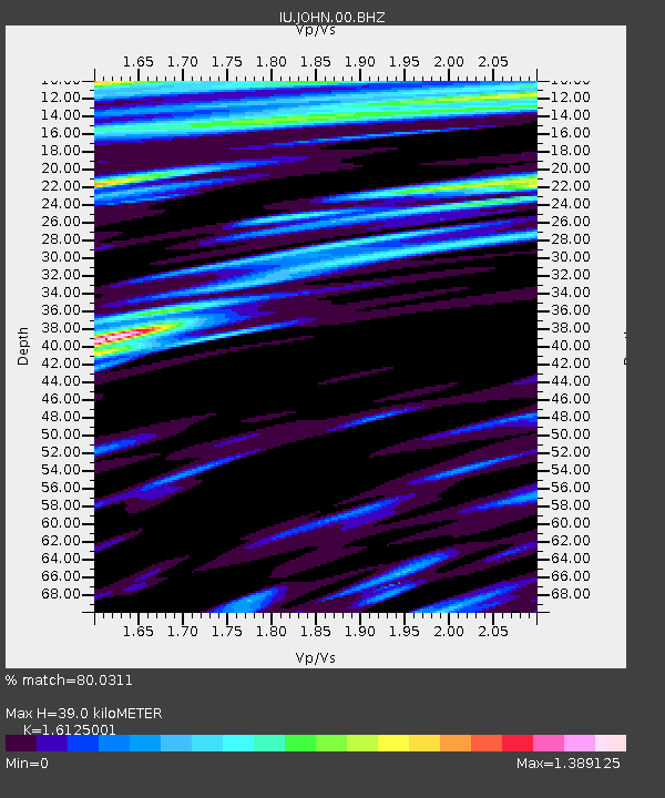
| Estimated Moho Depth: |
39.0 km |
| Estimated Crust Vp/Vs: |
1.61 |
| Assumed Crust Vp: |
4.24 km/s |
| Estimated Crust Vs: |
2.629 km/s |
| Estimated Crust Poisson's Ratio: |
0.19 |
|
| Radial Match: |
80.0311 % |
| Radial Bump: |
391 |
| Transverse Match: |
70.546776 % |
| Transverse Bump: |
374 |
| SOD ConfigId: |
1085051 |
| Insert Time: |
2015-08-10 05:12:59.016 +0000 |
| GWidth: |
2.5 |
| Max Bumps: |
400 |
| Tol: |
0.001 |
|

Signal To Noise
| Channel | StoN | STA | LTA |
| IU:JOHN:00:BHZ:20150727T04:56:10.343988Z | 3.3000894 | 3.4202787E-6 | 1.03642E-6 |
| IU:JOHN:00:BH1:20150727T04:56:10.343988Z | 1.208046 | 2.0445118E-6 | 1.6924123E-6 |
| IU:JOHN:00:BH2:20150727T04:56:10.343988Z | 1.6571119 | 2.0169591E-6 | 1.2171532E-6 |
| Arrivals |
| Ps | 5.8 SECOND |
| PpPs | 23 SECOND |
| PsPs/PpSs | 29 SECOND |


