You are here: Home > Network List > AK - Alaska Regional Network Stations List
> Station BARN Barnard Glacier, AK, USA > Earthquake Result Viewer
BARN Barnard Glacier, AK, USA - Earthquake Result Viewer
| Earthquake location: |
Vanuatu Islands |
| Earthquake latitude/longitude: |
-14.0/166.6 |
| Earthquake time(UTC): |
2016/04/07 (098) 03:32:53 GMT |
| Earthquake Depth: |
27 km |
| Earthquake Magnitude: |
6.7 MWW, 6.5 MWB, 6.9 MI |
| Earthquake Catalog/Contributor: |
NEIC PDE/NEIC COMCAT |
|
| Network: |
AK Alaska Regional Network |
| Station: |
BARN Barnard Glacier, AK, USA |
| Lat/Lon: |
61.06 N/141.66 W |
| Elevation: |
1689 m |
|
| Distance: |
85.3 deg |
| Az: |
22.542 deg |
| Baz: |
229.913 deg |
| Ray Param: |
0.0448446 |
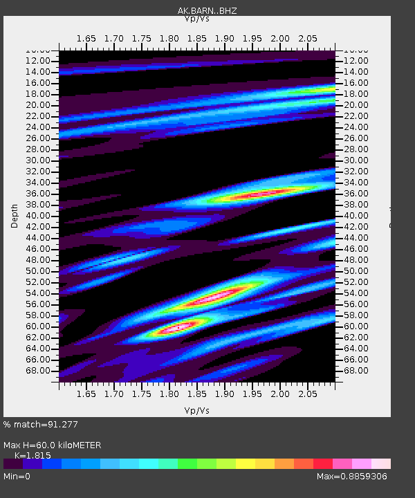
| Estimated Moho Depth: |
60.0 km |
| Estimated Crust Vp/Vs: |
1.82 |
| Assumed Crust Vp: |
6.566 km/s |
| Estimated Crust Vs: |
3.618 km/s |
| Estimated Crust Poisson's Ratio: |
0.28 |
|
| Radial Match: |
91.277 % |
| Radial Bump: |
400 |
| Transverse Match: |
61.216663 % |
| Transverse Bump: |
400 |
| SOD ConfigId: |
7422571 |
| Insert Time: |
2019-04-22 04:16:39.876 +0000 |
| GWidth: |
2.5 |
| Max Bumps: |
400 |
| Tol: |
0.001 |
|

Signal To Noise
| Channel | StoN | STA | LTA |
| AK:BARN: :BHZ:20160407T03:44:56.287986Z | 9.325191 | 2.056733E-6 | 2.2055666E-7 |
| AK:BARN: :BHN:20160407T03:44:56.287986Z | 3.4922643 | 8.378374E-7 | 2.3991237E-7 |
| AK:BARN: :BHE:20160407T03:44:56.287986Z | 2.3339393 | 4.8200087E-7 | 2.0651817E-7 |
| Arrivals |
| Ps | 7.6 SECOND |
| PpPs | 25 SECOND |
| PsPs/PpSs | 33 SECOND |


