You are here: Home > Network List > US - United States National Seismic Network Stations List
> Station MIAR Mount Ida, Arkansas, USA > Earthquake Result Viewer
MIAR Mount Ida, Arkansas, USA - Earthquake Result Viewer

| Earthquake location: |
Near Coast Of Peru |
| Earthquake latitude/longitude: |
-16.2/-73.9 |
| Earthquake time(UTC): |
2004/12/18 (353) 17:57:23 GMT |
| Earthquake Depth: |
28 km |
| Earthquake Magnitude: |
5.5 MB, 5.3 MS, 5.8 MW |
| Earthquake Catalog/Contributor: |
WHDF/NEIC |
|
| Network: |
US United States National Seismic Network |
| Station: |
MIAR Mount Ida, Arkansas, USA |
| Lat/Lon: |
34.55 N/93.58 W |
| Elevation: |
207 m |
|
| Distance: |
53.8 deg |
| Az: |
339.883 deg |
| Baz: |
156.401 deg |
| Ray Param: |
0.06579921 |
| Estimated Moho Depth: |
10.0 km |
| Estimated Crust Vp/Vs: |
1.60 |
| Assumed Crust Vp: |
6.498 km/s |
| Estimated Crust Vs: |
4.061 km/s |
| Estimated Crust Poisson's Ratio: |
0.18 |
|
| Radial Match: |
98.859184 % |
| Radial Bump: |
39 |
| Transverse Match: |
99.69422 % |
| Transverse Bump: |
24 |
| SOD ConfigId: |
110165 |
| Insert Time: |
2010-03-05 01:01:44.756 +0000 |
| GWidth: |
2.5 |
| Max Bumps: |
400 |
| Tol: |
0.001 |
|
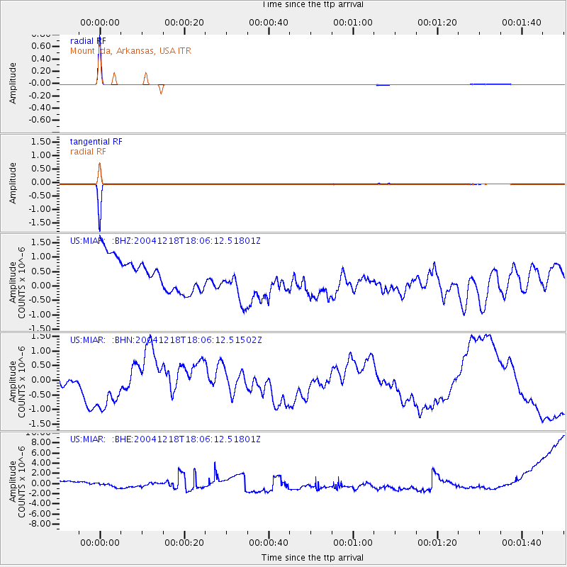
Signal To Noise
| Channel | StoN | STA | LTA |
| US:MIAR: :BHN:20041218T18:06:12.51502Z | 3.4939516 | 7.9193666E-7 | 2.2665931E-7 |
| US:MIAR: :BHE:20041218T18:06:12.51801Z | 0.42855635 | 7.1158786E-7 | 1.66043E-6 |
| US:MIAR: :BHZ:20041218T18:06:12.51801Z | 1.2580051 | 7.0616255E-7 | 5.613352E-7 |
| Arrivals |
| Ps | 1.0 SECOND |
| PpPs | 3.8 SECOND |
| PsPs/PpSs | 4.7 SECOND |


