You are here: Home > Network List > AK - Alaska Regional Network Stations List
> Station GAMB Gambell Broadband > Earthquake Result Viewer
GAMB Gambell Broadband - Earthquake Result Viewer
| Earthquake location: |
Vanuatu Islands |
| Earthquake latitude/longitude: |
-14.0/166.6 |
| Earthquake time(UTC): |
2016/04/07 (098) 03:32:53 GMT |
| Earthquake Depth: |
27 km |
| Earthquake Magnitude: |
6.7 MWW, 6.5 MWB, 6.9 MI |
| Earthquake Catalog/Contributor: |
NEIC PDE/NEIC COMCAT |
|
| Network: |
AK Alaska Regional Network |
| Station: |
GAMB Gambell Broadband |
| Lat/Lon: |
63.78 N/171.70 W |
| Elevation: |
10 m |
|
| Distance: |
79.3 deg |
| Az: |
9.635 deg |
| Baz: |
201.45 deg |
| Ray Param: |
0.049009122 |
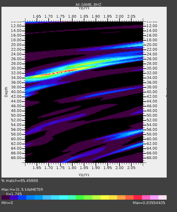
| Estimated Moho Depth: |
31.5 km |
| Estimated Crust Vp/Vs: |
1.75 |
| Assumed Crust Vp: |
6.24 km/s |
| Estimated Crust Vs: |
3.576 km/s |
| Estimated Crust Poisson's Ratio: |
0.26 |
|
| Radial Match: |
95.45988 % |
| Radial Bump: |
312 |
| Transverse Match: |
60.997967 % |
| Transverse Bump: |
400 |
| SOD ConfigId: |
7422571 |
| Insert Time: |
2019-04-22 04:16:55.876 +0000 |
| GWidth: |
2.5 |
| Max Bumps: |
400 |
| Tol: |
0.001 |
|
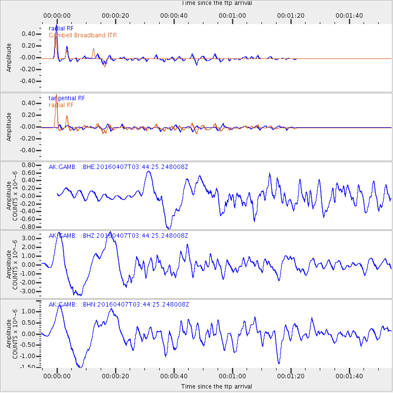
Signal To Noise
| Channel | StoN | STA | LTA |
| AK:GAMB: :BHZ:20160407T03:44:25.248008Z | 22.330698 | 2.4054132E-6 | 1.07717774E-7 |
| AK:GAMB: :BHN:20160407T03:44:25.248008Z | 5.7601166 | 8.327855E-7 | 1.445779E-7 |
| AK:GAMB: :BHE:20160407T03:44:25.248008Z | 4.379334 | 3.7375983E-7 | 8.534627E-8 |
| Arrivals |
| Ps | 3.9 SECOND |
| PpPs | 13 SECOND |
| PsPs/PpSs | 17 SECOND |


