You are here: Home > Network List > US - United States National Seismic Network Stations List
> Station MIAR Mount Ida, Arkansas, USA > Earthquake Result Viewer
MIAR Mount Ida, Arkansas, USA - Earthquake Result Viewer
| Earthquake location: |
Near Coast Of Northern Chile |
| Earthquake latitude/longitude: |
-22.9/-70.2 |
| Earthquake time(UTC): |
2007/11/15 (319) 15:05:58 GMT |
| Earthquake Depth: |
26 km |
| Earthquake Magnitude: |
6.1 MB, 6.6 MS, 6.8 MW, 6.6 MW |
| Earthquake Catalog/Contributor: |
WHDF/NEIC |
|
| Network: |
US United States National Seismic Network |
| Station: |
MIAR Mount Ida, Arkansas, USA |
| Lat/Lon: |
34.55 N/93.58 W |
| Elevation: |
207 m |
|
| Distance: |
61.3 deg |
| Az: |
338.111 deg |
| Baz: |
155.393 deg |
| Ray Param: |
0.0609201 |
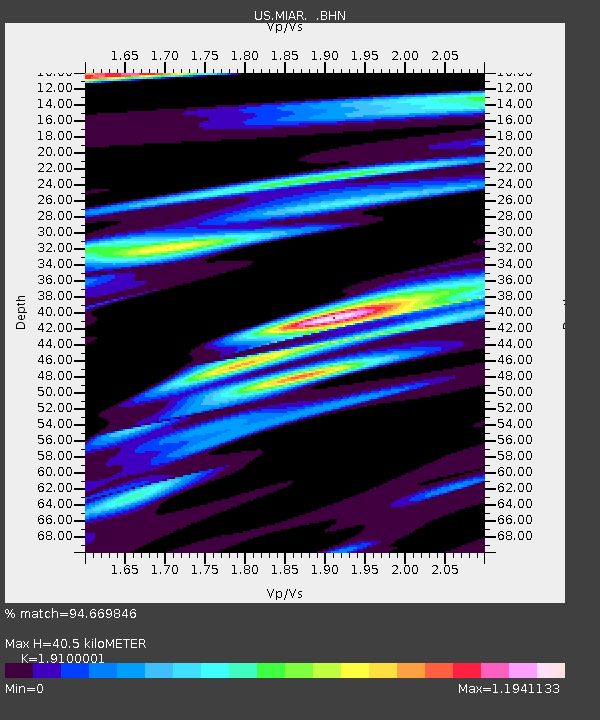
| Estimated Moho Depth: |
40.5 km |
| Estimated Crust Vp/Vs: |
1.91 |
| Assumed Crust Vp: |
6.498 km/s |
| Estimated Crust Vs: |
3.402 km/s |
| Estimated Crust Poisson's Ratio: |
0.31 |
|
| Radial Match: |
94.669846 % |
| Radial Bump: |
400 |
| Transverse Match: |
67.534775 % |
| Transverse Bump: |
400 |
| SOD ConfigId: |
2564 |
| Insert Time: |
2010-03-05 01:02:04.808 +0000 |
| GWidth: |
2.5 |
| Max Bumps: |
400 |
| Tol: |
0.001 |
|

Signal To Noise
| Channel | StoN | STA | LTA |
| US:MIAR: :BHN:20071115T15:15:40.547021Z | 1.9291786 | 5.304738E-7 | 2.7497393E-7 |
| US:MIAR: :BHE:20071115T15:15:40.547021Z | 1.4096091 | 2.3078485E-7 | 1.6372259E-7 |
| US:MIAR: :BHZ:20071115T15:15:40.547021Z | 2.3173451 | 8.500715E-7 | 3.668299E-7 |
| Arrivals |
| Ps | 5.9 SECOND |
| PpPs | 17 SECOND |
| PsPs/PpSs | 23 SECOND |


