You are here: Home > Network List > AK - Alaska Regional Network Stations List
> Station TRF Thorofare Mountian > Earthquake Result Viewer
TRF Thorofare Mountian - Earthquake Result Viewer
| Earthquake location: |
Vanuatu Islands |
| Earthquake latitude/longitude: |
-14.0/166.6 |
| Earthquake time(UTC): |
2016/04/07 (098) 03:32:53 GMT |
| Earthquake Depth: |
27 km |
| Earthquake Magnitude: |
6.7 MWW, 6.5 MWB, 6.9 MI |
| Earthquake Catalog/Contributor: |
NEIC PDE/NEIC COMCAT |
|
| Network: |
AK Alaska Regional Network |
| Station: |
TRF Thorofare Mountian |
| Lat/Lon: |
63.45 N/150.29 W |
| Elevation: |
1717 m |
|
| Distance: |
84.1 deg |
| Az: |
17.996 deg |
| Baz: |
221.864 deg |
| Ray Param: |
0.04572143 |
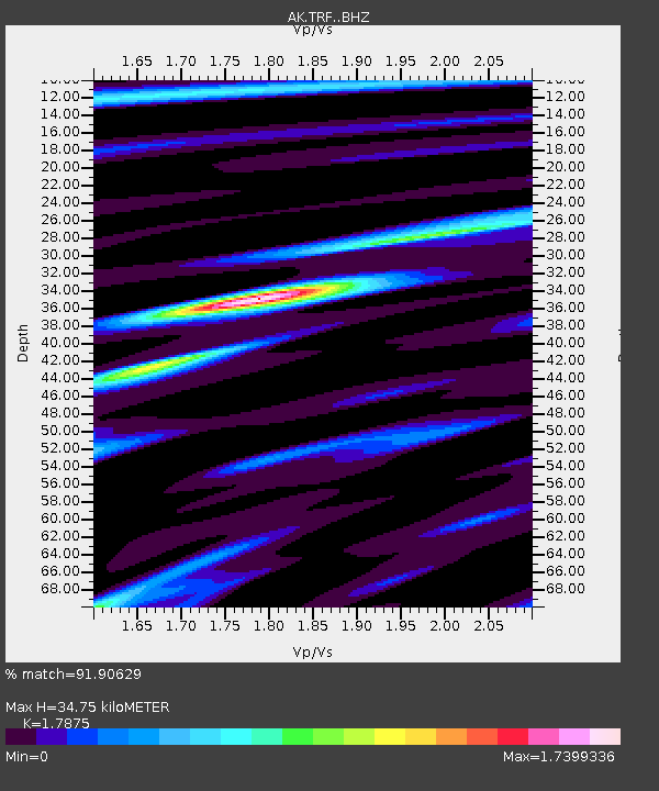
| Estimated Moho Depth: |
34.75 km |
| Estimated Crust Vp/Vs: |
1.79 |
| Assumed Crust Vp: |
6.438 km/s |
| Estimated Crust Vs: |
3.602 km/s |
| Estimated Crust Poisson's Ratio: |
0.27 |
|
| Radial Match: |
91.90629 % |
| Radial Bump: |
336 |
| Transverse Match: |
69.62161 % |
| Transverse Bump: |
400 |
| SOD ConfigId: |
7422571 |
| Insert Time: |
2019-04-22 04:17:27.574 +0000 |
| GWidth: |
2.5 |
| Max Bumps: |
400 |
| Tol: |
0.001 |
|

Signal To Noise
| Channel | StoN | STA | LTA |
| AK:TRF: :BHZ:20160407T03:44:50.107993Z | 10.64688 | 2.151057E-6 | 2.0203638E-7 |
| AK:TRF: :BHN:20160407T03:44:50.107993Z | 3.0178988 | 6.437997E-7 | 2.1332713E-7 |
| AK:TRF: :BHE:20160407T03:44:50.107993Z | 3.0620656 | 7.8542894E-7 | 2.5650297E-7 |
| Arrivals |
| Ps | 4.4 SECOND |
| PpPs | 15 SECOND |
| PsPs/PpSs | 19 SECOND |


