MIAR Mount Ida, Arkansas, USA - Earthquake Result Viewer
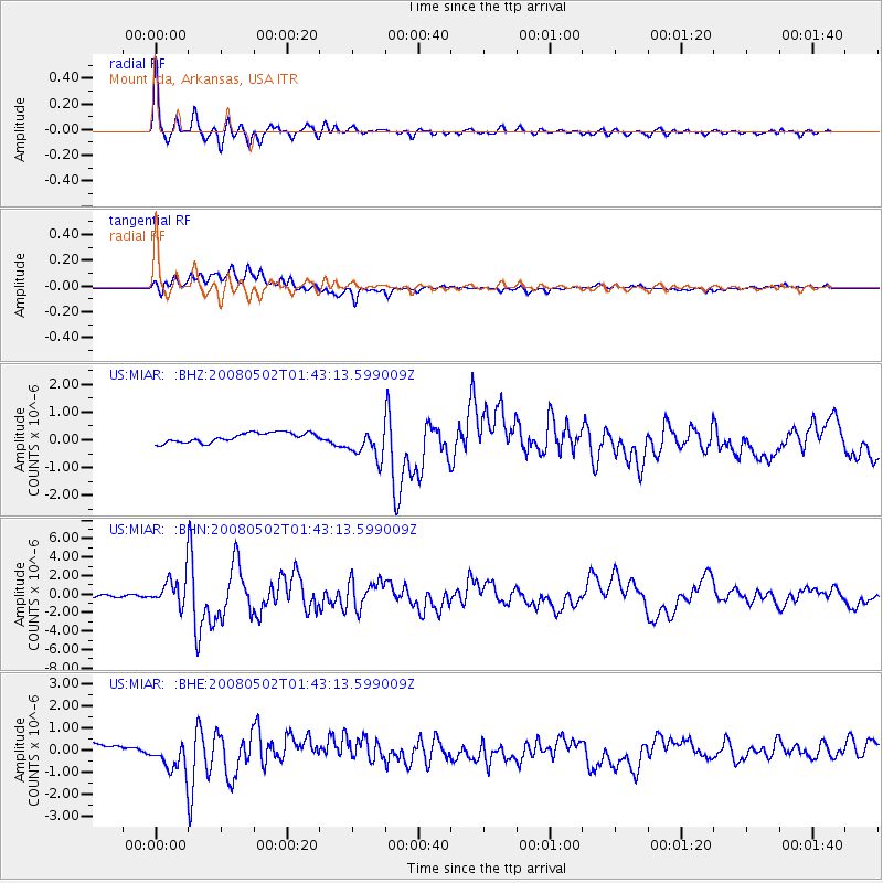
Earthquake location: Andreanof Islands, Aleutian Is.
Earthquake latitude/longitude: 51.9/-177.5
Earthquake time(UTC): 2008/05/02 (123) 01:33:37 GMT
Earthquake Depth: 14 km
Earthquake Magnitude: 6.3 MB, 6.8 MS, 6.6 MW, 6.6 MW
Earthquake Catalog/Contributor: WHDF/NEIC
Network: US United States National Seismic Network
Station: MIAR Mount Ida, Arkansas, USA
Lat/Lon: 34.55 N/93.58 W
Elevation: 207 m
Distance: 60.2 deg
Az: 71.053 deg
Baz: 314.723 deg
Ray Param: 0.06167224
Estimated Moho Depth: 28.0 km
Estimated Crust Vp/Vs: 1.71
Assumed Crust Vp: 6.498 km/s
Estimated Crust Vs: 3.794 km/s
Estimated Crust Poisson's Ratio: 0.24
Radial Match: 95.94675 %
Radial Bump: 360
Transverse Match: 44.673412 %
Transverse Bump: 400
SOD ConfigId: 2504
Insert Time: 2010-03-05 01:02:53.348 +0000
GWidth: 2.5
Max Bumps: 400
Tol: 0.001

Signal To Noise

ChannelStoNSTALTA
US:MIAR: :BHN:20080502T01:43:13.599009Z18.6369271.54195E-68.273628E-8
US:MIAR: :BHE:20080502T01:43:13.599009Z3.09661487.069407E-72.2829468E-7
US:MIAR: :BHZ:20080502T01:43:13.599009Z3.29941275.613426E-71.7013409E-7
Arrivals
Ps3.2 SECOND
PpPs11 SECOND
PsPs/PpSs14 SECOND