You are here: Home > Network List > CI - Caltech Regional Seismic Network Stations List
> Station SWS Sam W. Stewart, Westmorland, CA, USA > Earthquake Result Viewer
SWS Sam W. Stewart, Westmorland, CA, USA - Earthquake Result Viewer

| Earthquake location: |
Vanuatu Islands |
| Earthquake latitude/longitude: |
-14.0/166.6 |
| Earthquake time(UTC): |
2016/04/07 (098) 03:32:53 GMT |
| Earthquake Depth: |
27 km |
| Earthquake Magnitude: |
6.7 MWW, 6.5 MWB, 6.9 MI |
| Earthquake Catalog/Contributor: |
NEIC PDE/NEIC COMCAT |
|
| Network: |
CI Caltech Regional Seismic Network |
| Station: |
SWS Sam W. Stewart, Westmorland, CA, USA |
| Lat/Lon: |
32.94 N/115.80 W |
| Elevation: |
140 m |
|
| Distance: |
87.4 deg |
| Az: |
55.306 deg |
| Baz: |
251.646 deg |
| Ray Param: |
0.043299094 |
| Estimated Moho Depth: |
41.5 km |
| Estimated Crust Vp/Vs: |
2.01 |
| Assumed Crust Vp: |
6.155 km/s |
| Estimated Crust Vs: |
3.07 km/s |
| Estimated Crust Poisson's Ratio: |
0.33 |
|
| Radial Match: |
85.87326 % |
| Radial Bump: |
342 |
| Transverse Match: |
72.53391 % |
| Transverse Bump: |
400 |
| SOD ConfigId: |
7422571 |
| Insert Time: |
2019-04-22 04:19:31.784 +0000 |
| GWidth: |
2.5 |
| Max Bumps: |
400 |
| Tol: |
0.001 |
|
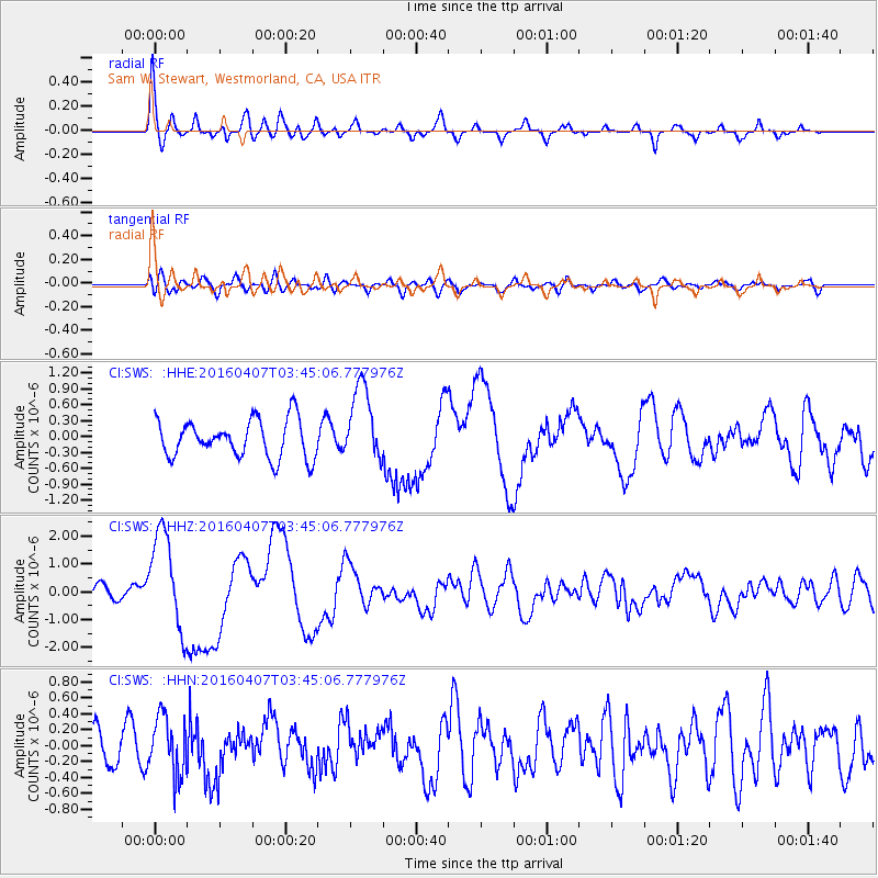
Signal To Noise
| Channel | StoN | STA | LTA |
| CI:SWS: :HHZ:20160407T03:45:06.777976Z | 8.893786 | 1.7729936E-6 | 1.9935194E-7 |
| CI:SWS: :HHN:20160407T03:45:06.777976Z | 2.149324 | 3.6490172E-7 | 1.6977512E-7 |
| CI:SWS: :HHE:20160407T03:45:06.777976Z | 2.0872421 | 7.3250465E-7 | 3.509438E-7 |
| Arrivals |
| Ps | 6.9 SECOND |
| PpPs | 20 SECOND |
| PsPs/PpSs | 27 SECOND |


