You are here: Home > Network List > IW - Intermountain West Stations List
> Station IMW Indian Meadow, Wyoming, USA > Earthquake Result Viewer
IMW Indian Meadow, Wyoming, USA - Earthquake Result Viewer
| Earthquake location: |
Fox Islands, Aleutian Islands |
| Earthquake latitude/longitude: |
52.4/-169.7 |
| Earthquake time(UTC): |
2015/07/27 (208) 04:49:44 GMT |
| Earthquake Depth: |
12 km |
| Earthquake Magnitude: |
6.9 MO |
| Earthquake Catalog/Contributor: |
NEIC PDE/NEIC ALERT |
|
| Network: |
IW Intermountain West |
| Station: |
IMW Indian Meadow, Wyoming, USA |
| Lat/Lon: |
43.90 N/110.94 W |
| Elevation: |
2646 m |
|
| Distance: |
39.1 deg |
| Az: |
78.382 deg |
| Baz: |
303.834 deg |
| Ray Param: |
0.075171776 |
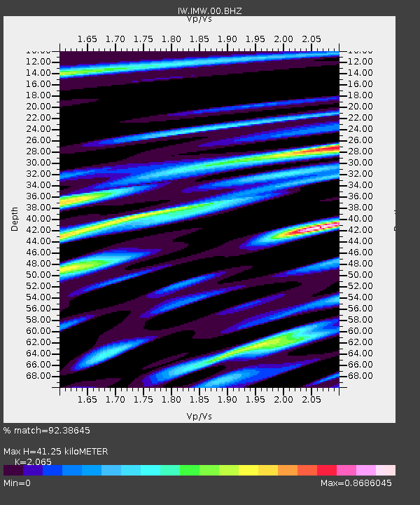
| Estimated Moho Depth: |
41.25 km |
| Estimated Crust Vp/Vs: |
2.07 |
| Assumed Crust Vp: |
6.207 km/s |
| Estimated Crust Vs: |
3.006 km/s |
| Estimated Crust Poisson's Ratio: |
0.35 |
|
| Radial Match: |
92.38645 % |
| Radial Bump: |
337 |
| Transverse Match: |
74.26097 % |
| Transverse Bump: |
400 |
| SOD ConfigId: |
1085051 |
| Insert Time: |
2015-08-10 05:14:40.524 +0000 |
| GWidth: |
2.5 |
| Max Bumps: |
400 |
| Tol: |
0.001 |
|

Signal To Noise
| Channel | StoN | STA | LTA |
| IW:IMW:00:BHZ:20150727T04:56:40.325006Z | 12.876629 | 9.0488936E-7 | 7.027378E-8 |
| IW:IMW:00:BH1:20150727T04:56:40.325006Z | 8.4308605 | 3.630895E-7 | 4.306672E-8 |
| IW:IMW:00:BH2:20150727T04:56:40.325006Z | 12.673231 | 4.6269707E-7 | 3.6509796E-8 |
| Arrivals |
| Ps | 7.5 SECOND |
| PpPs | 19 SECOND |
| PsPs/PpSs | 27 SECOND |


