You are here: Home > Network List > US - United States National Seismic Network Stations List
> Station MIAR Mount Ida, Arkansas, USA > Earthquake Result Viewer
MIAR Mount Ida, Arkansas, USA - Earthquake Result Viewer
| Earthquake location: |
Tonga Islands |
| Earthquake latitude/longitude: |
-21.9/-173.8 |
| Earthquake time(UTC): |
2008/10/19 (293) 05:10:33 GMT |
| Earthquake Depth: |
29 km |
| Earthquake Magnitude: |
6.8 MB, 7.0 MS, 6.9 MW, 6.9 MW |
| Earthquake Catalog/Contributor: |
WHDF/NEIC |
|
| Network: |
US United States National Seismic Network |
| Station: |
MIAR Mount Ida, Arkansas, USA |
| Lat/Lon: |
34.55 N/93.58 W |
| Elevation: |
207 m |
|
| Distance: |
94.5 deg |
| Az: |
54.692 deg |
| Baz: |
246.689 deg |
| Ray Param: |
0.041010756 |
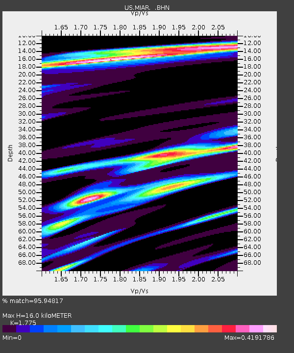
| Estimated Moho Depth: |
16.0 km |
| Estimated Crust Vp/Vs: |
1.77 |
| Assumed Crust Vp: |
6.498 km/s |
| Estimated Crust Vs: |
3.661 km/s |
| Estimated Crust Poisson's Ratio: |
0.27 |
|
| Radial Match: |
95.94817 % |
| Radial Bump: |
400 |
| Transverse Match: |
81.59173 % |
| Transverse Bump: |
400 |
| SOD ConfigId: |
2556 |
| Insert Time: |
2010-03-05 01:03:14.961 +0000 |
| GWidth: |
2.5 |
| Max Bumps: |
400 |
| Tol: |
0.001 |
|

Signal To Noise
| Channel | StoN | STA | LTA |
| US:MIAR: :BHN:20081019T05:23:20.074001Z | 17.338987 | 2.8980603E-6 | 1.6714127E-7 |
| US:MIAR: :BHE:20081019T05:23:20.074001Z | 6.760072 | 5.857776E-7 | 8.665257E-8 |
| US:MIAR: :BHZ:20081019T05:23:20.074001Z | 6.131831 | 8.353492E-7 | 1.362316E-7 |
| Arrivals |
| Ps | 1.9 SECOND |
| PpPs | 6.7 SECOND |
| PsPs/PpSs | 8.6 SECOND |


