You are here: Home > Network List > CI - Caltech Regional Seismic Network Stations List
> Station BAR Barrett, Tecate, CA, USA > Earthquake Result Viewer
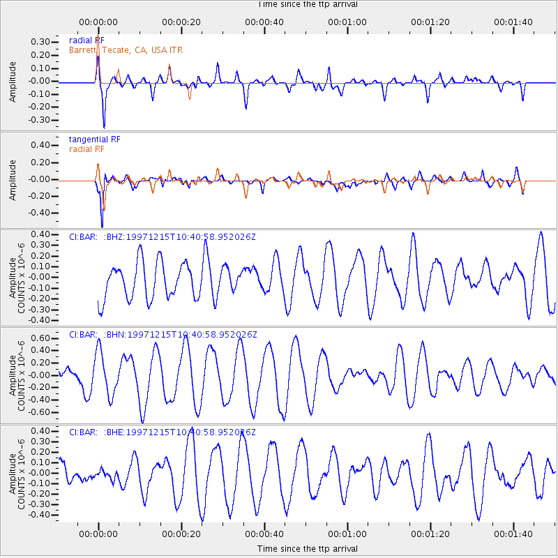
BAR Barrett, Tecate, CA, USA - Earthquake Result Viewer
*The percent match for this event was below the threshold and hence no stack was calculated.
| Earthquake location: |
New Britain Region, P.N.G. |
| Earthquake latitude/longitude: |
-6.0/149.9 |
| Earthquake time(UTC): |
1997/12/15 (349) 10:28:06 GMT |
| Earthquake Depth: |
33 km |
| Earthquake Magnitude: |
5.8 MS, 5.3 MB, 5.9 UNKNOWN, 5.9 MW |
| Earthquake Catalog/Contributor: |
WHDF/NEIC |
|
| Network: |
CI Caltech Regional Seismic Network |
| Station: |
BAR Barrett, Tecate, CA, USA |
| Lat/Lon: |
32.68 N/116.67 W |
| Elevation: |
521 m |
|
| Distance: |
96.1 deg |
| Az: |
57.849 deg |
| Baz: |
266.776 deg |
| Ray Param: |
$rayparam |
*The percent match for this event was below the threshold and hence was not used in the summary stack. |
|
| Radial Match: |
69.0714 % |
| Radial Bump: |
400 |
| Transverse Match: |
74.45348 % |
| Transverse Bump: |
400 |
| SOD ConfigId: |
4480 |
| Insert Time: |
2010-02-26 00:12:46.177 +0000 |
| GWidth: |
2.5 |
| Max Bumps: |
400 |
| Tol: |
0.001 |
|
Signal To Noise
| Channel | StoN | STA | LTA |
| CI:BAR: :BHN:19971215T10:40:58.952026Z | 2.090859 | 3.5370687E-7 | 1.6916822E-7 |
| CI:BAR: :BHE:19971215T10:40:58.952026Z | 0.40093544 | 6.441766E-8 | 1.606684E-7 |
| CI:BAR: :BHZ:19971215T10:40:58.952026Z | 0.5962624 | 9.9337775E-8 | 1.6660078E-7 |
| Arrivals |
| Ps | |
| PpPs | |
| PsPs/PpSs | |


