You are here: Home > Network List > US - United States National Seismic Network Stations List
> Station MIAR Mount Ida, Arkansas, USA > Earthquake Result Viewer
MIAR Mount Ida, Arkansas, USA - Earthquake Result Viewer
| Earthquake location: |
Peru-Ecuador Border Region |
| Earthquake latitude/longitude: |
-3.3/-81.0 |
| Earthquake time(UTC): |
2005/05/21 (141) 05:11:35 GMT |
| Earthquake Depth: |
40 km |
| Earthquake Magnitude: |
5.9 MB, 5.9 MS, 6.4 MW, 6.3 MW |
| Earthquake Catalog/Contributor: |
WHDF/NEIC |
|
| Network: |
US United States National Seismic Network |
| Station: |
MIAR Mount Ida, Arkansas, USA |
| Lat/Lon: |
34.55 N/93.58 W |
| Elevation: |
207 m |
|
| Distance: |
39.5 deg |
| Az: |
343.552 deg |
| Baz: |
159.973 deg |
| Ray Param: |
0.07488921 |
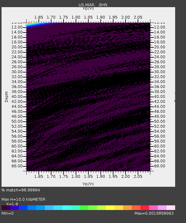
| Estimated Moho Depth: |
10.0 km |
| Estimated Crust Vp/Vs: |
1.60 |
| Assumed Crust Vp: |
6.498 km/s |
| Estimated Crust Vs: |
4.061 km/s |
| Estimated Crust Poisson's Ratio: |
0.18 |
|
| Radial Match: |
99.99994 % |
| Radial Bump: |
2 |
| Transverse Match: |
99.99981 % |
| Transverse Bump: |
2 |
| SOD ConfigId: |
110165 |
| Insert Time: |
2010-03-05 01:03:41.591 +0000 |
| GWidth: |
2.5 |
| Max Bumps: |
400 |
| Tol: |
0.001 |
|

Signal To Noise
| Channel | StoN | STA | LTA |
| US:MIAR: :BHN:20050521T05:18:31.349015Z | 0.90306985 | 8.5406E-7 | 9.457297E-7 |
| US:MIAR: :BHE:20050521T05:18:31.349015Z | 0.90508837 | 7.0955656E-7 | 7.839638E-7 |
| US:MIAR: :BHZ:20050521T05:18:31.349015Z | 0.8951393 | 4.865344E-7 | 5.4352927E-7 |
| Arrivals |
| Ps | 1.0 SECOND |
| PpPs | 3.7 SECOND |
| PsPs/PpSs | 4.7 SECOND |


