You are here: Home > Network List > CI - Caltech Regional Seismic Network Stations List
> Station BAR Barrett, Tecate, CA, USA > Earthquake Result Viewer
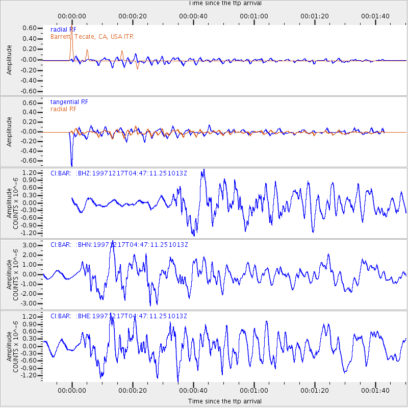
BAR Barrett, Tecate, CA, USA - Earthquake Result Viewer
*The percent match for this event was below the threshold and hence no stack was calculated.
| Earthquake location: |
Rat Islands, Aleutian Islands |
| Earthquake latitude/longitude: |
51.2/178.9 |
| Earthquake time(UTC): |
1997/12/17 (351) 04:38:51 GMT |
| Earthquake Depth: |
20 km |
| Earthquake Magnitude: |
5.8 MB, 6.5 MS, 6.7 UNKNOWN, 6.1 ME |
| Earthquake Catalog/Contributor: |
WHDF/NEIC |
|
| Network: |
CI Caltech Regional Seismic Network |
| Station: |
BAR Barrett, Tecate, CA, USA |
| Lat/Lon: |
32.68 N/116.67 W |
| Elevation: |
521 m |
|
| Distance: |
49.7 deg |
| Az: |
85.821 deg |
| Baz: |
311.905 deg |
| Ray Param: |
$rayparam |
*The percent match for this event was below the threshold and hence was not used in the summary stack. |
|
| Radial Match: |
74.44351 % |
| Radial Bump: |
400 |
| Transverse Match: |
88.56323 % |
| Transverse Bump: |
400 |
| SOD ConfigId: |
4480 |
| Insert Time: |
2010-02-26 00:12:48.802 +0000 |
| GWidth: |
2.5 |
| Max Bumps: |
400 |
| Tol: |
0.001 |
|
Signal To Noise
| Channel | StoN | STA | LTA |
| CI:BAR: :BHN:19971217T04:47:11.251013Z | 2.430233 | 5.70662E-7 | 2.348178E-7 |
| CI:BAR: :BHE:19971217T04:47:11.251013Z | 1.6609462 | 2.656742E-7 | 1.5995353E-7 |
| CI:BAR: :BHZ:19971217T04:47:11.251013Z | 1.7443042 | 2.1244286E-7 | 1.2179233E-7 |
| Arrivals |
| Ps | |
| PpPs | |
| PsPs/PpSs | |


