You are here: Home > Network List > TA - USArray Transportable Network (new EarthScope stations) Stations List
> Station K02D Willamette Meridian, OR, USA > Earthquake Result Viewer
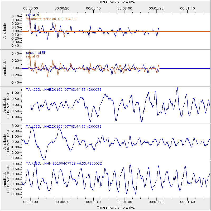
K02D Willamette Meridian, OR, USA - Earthquake Result Viewer

| Earthquake location: |
Vanuatu Islands |
| Earthquake latitude/longitude: |
-14.0/166.6 |
| Earthquake time(UTC): |
2016/04/07 (098) 03:32:53 GMT |
| Earthquake Depth: |
27 km |
| Earthquake Magnitude: |
6.7 MWW, 6.5 MWB, 6.9 MI |
| Earthquake Catalog/Contributor: |
NEIC PDE/NEIC COMCAT |
|
| Network: |
TA USArray Transportable Network (new EarthScope stations) |
| Station: |
K02D Willamette Meridian, OR, USA |
| Lat/Lon: |
42.70 N/123.67 W |
| Elevation: |
989 m |
|
| Distance: |
85.1 deg |
| Az: |
43.967 deg |
| Baz: |
246.079 deg |
| Ray Param: |
0.0449663 |
| Estimated Moho Depth: |
37.5 km |
| Estimated Crust Vp/Vs: |
1.60 |
| Assumed Crust Vp: |
6.522 km/s |
| Estimated Crust Vs: |
4.076 km/s |
| Estimated Crust Poisson's Ratio: |
0.18 |
|
| Radial Match: |
80.98339 % |
| Radial Bump: |
400 |
| Transverse Match: |
74.94218 % |
| Transverse Bump: |
400 |
| SOD ConfigId: |
7422571 |
| Insert Time: |
2019-04-22 04:22:30.146 +0000 |
| GWidth: |
2.5 |
| Max Bumps: |
400 |
| Tol: |
0.001 |
|
Signal To Noise
| Channel | StoN | STA | LTA |
| TA:K02D: :HHZ:20160407T03:44:55.420005Z | 5.2640347 | 1.7708448E-6 | 3.3640447E-7 |
| TA:K02D: :HHN:20160407T03:44:55.420005Z | 2.3606646 | 5.172438E-7 | 2.1910938E-7 |
| TA:K02D: :HHE:20160407T03:44:55.420005Z | 2.2283328 | 4.7359205E-7 | 2.1253202E-7 |
| Arrivals |
| Ps | 3.5 SECOND |
| PpPs | 15 SECOND |
| PsPs/PpSs | 18 SECOND |


